Within UFO Identifications
When the Atmosphere Itself Looks Like a UFO
Unusual clouds, illuminated layers and changing atmospheric structure can produce shapes or lights that appear solid and mobile.
On this page
- Cloud shapes and unusual illumination
- How changing perspective creates apparent motion
- Weather records that test atmospheric explanations
Page outline Jump by section
Introduction
Clouds do not have to resemble ordinary fluffy clouds to generate UFO or UAP reports. Under the right combination of wind, moisture, sunlight and viewing geometry, the atmosphere can produce smooth discs, stacked ovals, sharply bounded luminous patches and apparently stationary objects that seem much more solid than they are. Lenticular clouds are the clearest example: both the UK Met Office and the US National Weather Service explicitly note their resemblance to flying saucers and their history of being mistaken for UFOs.[Met Office]weather.metoffice.gov.ukMet OfficeUnusual cloud formationsNacreous clouds are rare and very high clouds, known mainly for the coloured light they reflect after s…
The important point is not simply that “some UFOs are clouds”. Atmospheric misidentification becomes persuasive only when the proposed mechanism explains the particular shape, brightness, persistence and apparent motion that witnesses reported. This is why weather records matter. Wind profiles, humidity, satellite imagery and the position of the Sun or Moon can sometimes turn a vague cloud hypothesis into a testable reconstruction — or rule it out.

Cloud shapes and unusual illumination
The most UFO-like clouds are produced when the atmosphere organises itself into structures that look surprisingly geometric. Ordinary turbulent cloud tends to have irregular edges, so a smooth oval or sharply outlined dome can give an observer a strong impression that they are looking at a manufactured object rather than condensed water droplets.
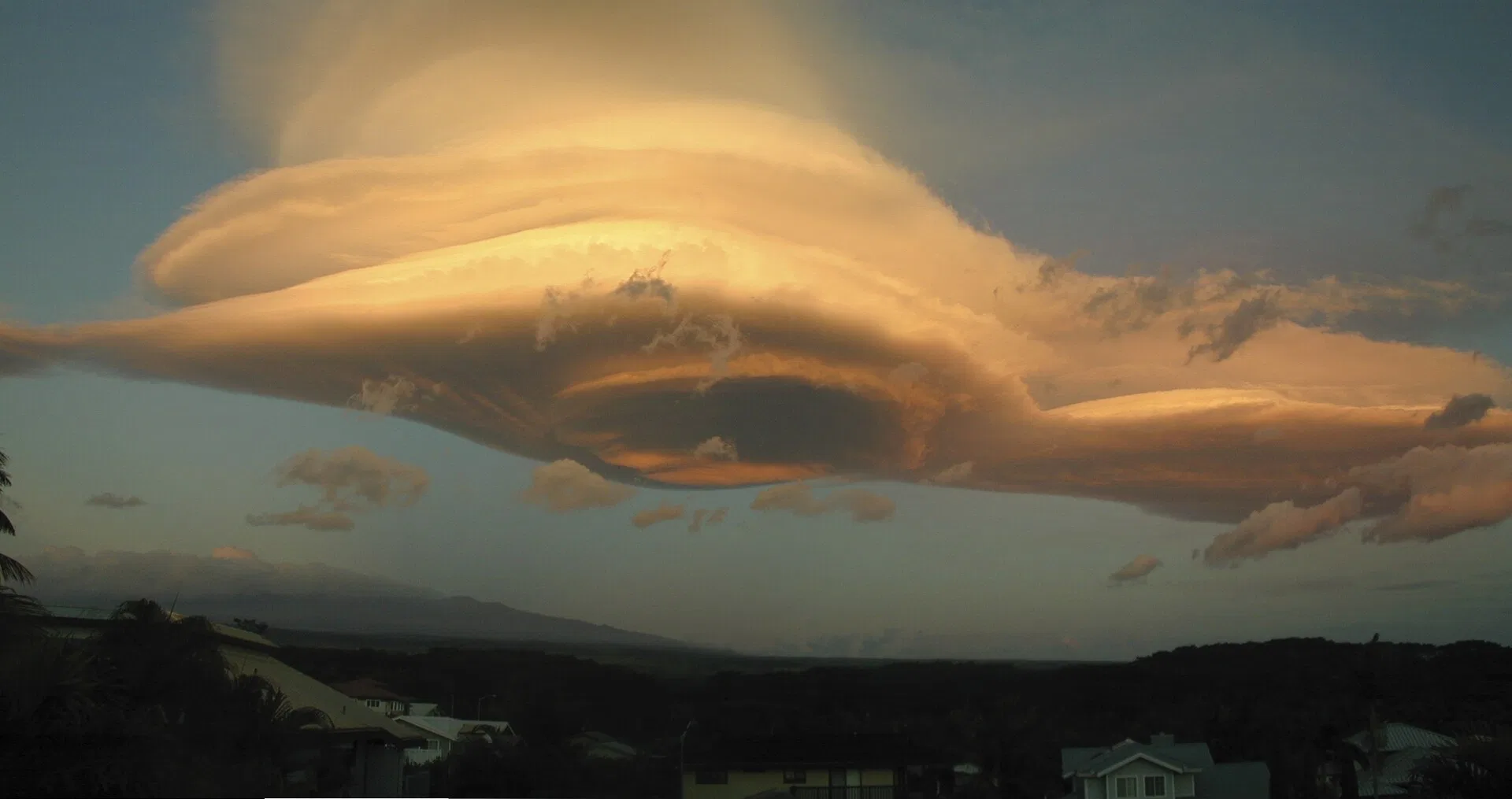
Lenticular clouds are the classic case. Their name comes from their lens-like profile. They commonly develop when stable, moist air flows across hills or mountains and is forced into a series of standing atmospheric waves. Air rising towards the crest of a wave cools; if it reaches saturation, cloud forms. As that air descends again, the droplets evaporate. The result can be a smooth lens or a stack of lenses positioned downwind of high ground.[Met Office]weather.metoffice.gov.ukMet OfficeUnusual cloud formationsNacreous clouds are rare and very high clouds, known mainly for the coloured light they reflect after s…
That mechanism produces one particularly deceptive feature: the visible cloud can remain nearly fixed while strong winds pass through it. The National Weather Service explains that water is continually condensing near the wave crest and dissipating immediately downwind. The cloud therefore appears stationary even though the air composing it is moving rapidly.[National Weather Service]weather.govNational Weather ServiceAltocumulus Standing Lenticular CloudsWhen sufficient moisture is present above mountain-top level, ACSL clouds d… A witness expecting every cloud to drift with the wind may reasonably interpret a smooth formation that “hovers” in one place as something fundamentally different.
Terrain provides a useful diagnostic clue. The National Weather Service documented long-lasting lenticular clouds over Hawaii’s Big Island on 25 November 2003 after winds of roughly 40–60 mph at elevations above 10,000 feet crossed Mauna Loa and Mauna Kea, generating atmospheric waves downwind of the summits.[National Weather Service]weather.govThey are fairly common over the western half of the mainland…Read more… Similar displays occur around major ranges and isolated mountains worldwide. In Britain they are less common, but the Met Office records them and identifies lee waves over hills and mountains as their normal setting.[Met Office]weather.metoffice.gov.ukMet OfficeUnusual cloud formationsNacreous clouds are rare and very high clouds, known mainly for the coloured light they reflect after s…
Lenticular clouds are not the only formations capable of looking anomalously structured. Roll clouds and other wave-related clouds can create long tubular or layered forms, while high-altitude clouds sometimes present shapes and brightness quite unlike familiar low cloud. The broader lesson is that apparently “engineered” smoothness is not, by itself, evidence that a sighting involved a solid craft.
Illumination can make such shapes more convincing still. A cloud may be physically diffuse yet have a bright, sharply defined edge where sunlight strikes one region while neighbouring cloud remains shadowed. Around sunrise and sunset, the geometry changes quickly enough for a formation to brighten, fade or apparently alter its structure over minutes.
Some rarer clouds remain sunlit even when the observer’s lower atmosphere is already dark. Nacreous clouds, which form in the lower stratosphere under extremely cold conditions, can show brilliant iridescent colours after sunset or before sunrise because their altitude leaves them illuminated when the Sun is below the local horizon. The Met Office notes that they are especially visible with the Sun roughly 1°–6° below the horizon.[Met Office]weather.metoffice.gov.ukMet OfficeUnusual cloud formationsNacreous clouds are rare and very high clouds, known mainly for the coloured light they reflect after s… The World Meteorological Organization likewise describes their intense post-sunset iridescence.[International Cloud Atlas]cloudatlas.wmo.intInternational Cloud AtlasNacreous cloudsBy day, nacreous clouds often resemble pale Cirrus. After sunset, they are characterized by brill…
Noctilucent clouds operate on an even larger altitude difference. Forming in the mesosphere, they can remain illuminated well into twilight and appear as silver-blue structures against an otherwise dark sky. Their great height — rather than any internal light source — allows sunlight to reach them after lower clouds have entered Earth’s shadow.[Met Office]weather.metoffice.gov.ukMet OfficeUnusual cloud formationsNacreous clouds are rare and very high clouds, known mainly for the coloured light they reflect after s… In a brief observation without distance or altitude cues, unusual twilight illumination can therefore make atmospheric material appear self-luminous.
Other optical effects can concentrate light into apparently discrete features. The World Meteorological Organization classifies halos as rings, arcs, pillars or bright spots created when light is refracted or reflected by ice crystals.[International Cloud Atlas]cloudatlas.wmo.intInternational Cloud AtlasHalo PhenomenaA group of optical phenomena in the form of rings, arcs, pillars or bright spots, produced by the… A light pillar, for example, is not a vertical luminous object suspended in the atmosphere. It is a reflection effect involving numerous ice crystals whose combined glints appear to the observer as a column. NOAA describes similar pillars above artificial lights in cold, ice-laden air and notes that sun pillars can occur near sunrise or sunset in association with thin cirrus.[NOAA Physical Sciences Laboratory]psl.noaa.govPhysical Sciences Laboratory Glittering Light on WaterPhysical Sciences Laboratory Glittering Light on Water
Cloud iridescence adds another route to unusual colour. The National Weather Service defines it as bright coloured spots, bands or borders produced when light is diffracted by small cloud particles, often in thin high or middle-level cloud relatively close to the Sun.[National Weather Service]weather.govNational Weather Service NOAA's National Weather ServiceNational Weather Service NOAA's National Weather Service Such effects are ordinarily recognisable when viewed in context, but an isolated photograph, narrow field of view or brief glimpse can remove the Sun, surrounding cloud and horizon cues that make the phenomenon obvious.
What matters for UFO identification is therefore the combination. A smooth cloud can supply the “body”; unusual solar illumination can supply the glow; gaps or shadows can produce apparent dark regions; and changes in condensation can cause sections to appear or vanish. None requires a solid object even though the resulting visual impression may be strongly object-like.
How changing perspective creates apparent motion
The atmosphere also complicates estimates of movement. Human observers judge speed partly from assumptions about size and distance. If neither is known, angular motion across the sky does not by itself reveal physical velocity. A small nearby feature and a very large distant feature can sweep through the same angle while moving at radically different speeds.
Lenticular clouds create an especially counter-intuitive version of this problem because they are standing patterns rather than fixed packets of air. Winds may race through the formation while condensation keeps rebuilding the visible cloud in roughly the same place.[National Weather Service]weather.govNational Weather ServiceAltocumulus Standing Lenticular CloudsWhen sufficient moisture is present above mountain-top level, ACSL clouds d… From the ground this can resemble hovering. From a moving aircraft or vehicle, however, the observer’s own changing position alters the line of sight to the cloud and surrounding landscape. A distant stationary formation can consequently seem to slide relative to nearer terrain.
This is ordinary perspective, but it becomes powerful when the scene lacks reference points. Against a featureless sky there may be no reliable indication whether an oval shape is hundreds of metres away or tens of kilometres away. Without range, an observer cannot confidently convert apparent angular displacement into kilometres per hour.
Clouds can also change while being watched. In a wave cloud, condensation forms continuously where rising air cools and disappears where descending air warms.[National Weather Service]weather.govNational Weather ServiceAltocumulus Standing Lenticular CloudsWhen sufficient moisture is present above mountain-top level, ACSL clouds d… The leading and trailing boundaries therefore need not represent the movement of the same droplets. A bright rim that develops at one edge while another fades can create a subjective impression of translation, rotation or acceleration even when the underlying atmospheric wave has barely shifted.
Illumination adds a second moving reference system. Near sunset, the position of the observer, cloud and solar rays changes continuously. Sunlit sections can brighten while adjacent portions fall into shadow. Thin cloud may become visible only where the scattering angle is favourable. To a witness who can see the luminous patch but not the faint cloud surrounding it, the light may appear to be an independent object moving through the sky.
This distinction is important when assessing descriptions such as “it suddenly accelerated” or “it vanished instantly”. Those observations may indeed describe a moving object, but they can also describe a changing visible portion of a much larger atmospheric structure. An identification therefore needs to ask whether the reported motion tracks a persistent physical outline or merely the brightest part of a changing scene.
Photography does not automatically solve the ambiguity. Exposure, contrast enhancement and cropping can suppress weak cloud while preserving a bright central region. A narrow field of view may remove hills, stars or the horizon needed to estimate motion. Conversely, a long sequence containing fixed landscape references is far more useful: investigators can determine whether the phenomenon actually changes angular position, merely changes shape, or remains aligned with terrain associated with mountain-wave formation.
Weather records can test the explanation
Calling an unexplained light “a cloud” is not much better than calling it “a spacecraft” unless the hypothesis can be checked. Atmospheric explanations become most useful when they make predictions about what the weather should have been doing at the reported time and place.
For a suspected lenticular cloud, investigators can ask whether there was suitable terrain upwind and whether the upper atmosphere contained reasonably strong, stable flow across it. The visible cloud also requires enough moisture at the relevant altitude for condensation. Surface weather alone may therefore be misleading: calm conditions at a witness’s location do not exclude strong winds several kilometres overhead.
Upper-air observations can provide that missing information. National Weather Service radiosondes measure pressure, temperature, relative humidity and GPS position as they ascend, allowing wind speed and direction to be derived through the atmosphere.[National Weather Service]weather.govOpen source on weather.gov. NOAA’s Integrated Global Radiosonde Archive contains observations from more than 2,800 stations worldwide, with records extending back to 1905 at some sites.[NCEI]ncei.noaa.govNCEIIntegrated Global Radiosonde Archive (IGRANCEIIntegrated Global Radiosonde Archive (IGRA For a historical sighting near a sounding station, these measurements may show whether a moist layer and appropriate winds actually existed.
Where direct observations are sparse, meteorological reanalysis provides another check. Reanalysis combines historical observations with a numerical weather model to reconstruct the atmosphere systematically. ECMWF’s ERA5 dataset provides variables including temperature, pressure, wind and humidity at different levels, with hourly output available across many decades.[ECMWF]ecmwf.intERA5: the new reanalysis of weather and climate dataERA5: the new reanalysis of weather and climate data It cannot reproduce every individual small cloud, but it can show whether the large-scale atmospheric setup required by a proposed explanation was plausible.
Satellite imagery is potentially stronger evidence when the date and location fall within good coverage. NOAA maintains archives of geostationary satellite imagery, while GOES satellites provide repeated visible and infrared observations useful for monitoring cloud cover and atmospheric systems.[NOAA Satellite Service]nesdis.noaa.govSatellite Service Global Archive | NESDISSatellite Service Global Archive | NESDIS A cloud explanation gains weight if imagery shows a persistent cloud field or wave pattern in the correct direction at the relevant time. A confidently clear sky in the relevant sector would instead count against it.
The Sun’s position supplies another independent test. Iridescence is normally observed relatively near the Sun, while nacreous clouds are characteristically illuminated when the Sun is only a few degrees below the horizon.[National Weather Service]weather.govNational Weather Service NOAA's National Weather ServiceNational Weather Service NOAA's National Weather Service A claimed atmospheric-optics explanation should therefore reproduce the reported viewing direction and time. If the necessary illumination geometry was impossible, the explanation needs revision.
A practical atmospheric assessment consequently asks several linked questions:
- Was cloud actually present? Satellite imagery, local observations and witness photographs can establish the basic cloud environment.
- Was the upper-air structure suitable? Wind direction, stability and humidity can support or weaken a mountain-wave or layered-cloud explanation.
- Was there appropriate terrain? Lenticular clouds should make meteorological sense relative to hills, mountains or other disturbances of airflow.
- Does the lighting geometry work? The positions of the Sun or Moon should correspond to the reported glow, halo, iridescence or twilight illumination.
- Does the motion behave like atmosphere? Shape changes, stationary alignment with terrain and progressive brightening or fading may be more diagnostic than an eyewitness estimate of speed.
These tests are also valuable when the atmospheric hypothesis fails. Weather evidence should not be used merely to find any vaguely plausible natural explanation. A good identification must fit the observation better than competing possibilities.
Why atmosphere can look more solid than it is
Cloud-related UFO reports are memorable because they expose a weakness in everyday visual intuition. The eye is good at recognising familiar objects but poor at recovering absolute size and distance from an isolated shape in the sky. When the atmosphere produces smooth boundaries and concentrated illumination, the brain has enough information to perceive an apparent object but not enough to determine what that object actually consists of.
Lenticular clouds demonstrate the problem unusually well. Their form is structured by a standing atmospheric wave, so they can remain fixed despite strong airflow; condensation continually replenishes their smooth outline; and low-angle sunlight can make the edges appear sharply sculpted. That combination satisfies several intuitive expectations of a hovering craft at once. Meteorological agencies on both sides of the Atlantic specifically recognise their long association with UFO-like appearances.[National Weather Service]weather.govThey are fairly common over the western half of the mainland…Read more…
Rare high-altitude clouds and ice-crystal optics demonstrate a related problem with luminosity. Something that appears to shine after sunset need not be producing light. It may simply be high enough to remain in sunlight, or positioned so that droplets or crystals concentrate light towards the observer.[Met Office]weather.metoffice.gov.ukMet OfficeUnusual cloud formationsNacreous clouds are rare and very high clouds, known mainly for the coloured light they reflect after s…
The atmospheric explanation is strongest, then, not when investigators simply recognise a photograph as “cloud-like”, but when shape, location, wind, humidity, illumination and apparent motion all tell the same story. Conversely, a sighting should not be forced into this category when contemporaneous meteorological evidence contradicts it. That distinction preserves the broader meaning of an unidentified report: “unidentified” describes the state of the evidence, while an atmospheric IFO is an identification that has earned its place by matching the physical conditions under which the observation occurred.
Amazon book picks
Further Reading
Books and field guides related to When the Atmosphere Itself Looks Like a UFO. Use these as the next step if you want deeper reading beyond the article.

Light and Color in the Outdoors
First published 1993. Subjects: Color, Light, Popular works, Science: General Issues, Photographic equipment & techniques.
Color and Light in Nature
We live in a world of optical marvels - from the commonplace but beautiful rainbow, to the rare and eerie superior mirage. But how many o...
The Cloudspotter's Guide
Discusses the history, types, and cultural fascination with clouds and explains what they mean in terms of climate and weather.
A Field Guide to the Atmosphere
More than 400 photographs and line drawings illustrate every kind of atmospheric phenomenon: clouds of every type; storms, from cloudburs...
eBay marketplace picks
Marketplace Samples
Live-tested eBay searches with available results related to this page.
Selected fromUFO poster oneBay.co.uk.
Current eBay listing
I Want To Believe UFO Poster Giclée Fine Art Heavyweight Print
Current eBay listing
VINTAGE UFO FLYING SAUCERS COMIC ADVERTISING A2 POSTER PRINT

Endnotes
1.
Source: weather.gov
Link:https://www.weather.gov/hfo/lenticular
Source snippet
They are fairly common over the western half of the mainland...Read more...
2.
Source: weather.gov
Link:https://www.weather.gov/abq/features_acsl
Source snippet
National Weather ServiceAltocumulus Standing Lenticular CloudsWhen sufficient moisture is present above mountain-top level, ACSL clouds d...
3.
Source: psl.noaa.gov
Title: Physical Sciences Laboratory Glittering Light on Water
Link:https://psl.noaa.gov/outreach/education/science/glitter/
4.
Source: weather.gov
Title: National Weather Service NOAA’s National Weather Service
Link:https://www.weather.gov/glossary/glossary.php?word=s
5.
Source: weather.gov
Link:https://www.weather.gov/upperair/factsheet
6.
Source: ncei.noaa.gov
Title: NCEIIntegrated Global Radiosonde Archive (IGRA)
Link:https://www.ncei.noaa.gov/products/weather-balloon/integrated-global-radiosonde-archive
7.
Source: ecmwf.int
Title: ERA5: the new reanalysis of weather and climate data
Link:https://www.ecmwf.int/en/about/media-centre/science-blog/2017/era5-new-reanalysis-weather-and-climate-data
8.
Source: ecmwf.int
Link:https://www.ecmwf.int/en/forecasts/datasets/search?order=asc&page=32&sort=field_ext_dataset_portal
9.
Source: nesdis.noaa.gov
Title: Satellite Service Global Archive | NESDIS
Link:https://www.nesdis.noaa.gov/imagery/interactive-maps/global-archive
10.
Source: nesdis.noaa.gov
Link:https://www.nesdis.noaa.gov/our-satellites/related-information/history-of-noaa-satellites/goes-history
11.
Source: nesdis.noaa.gov
Title: types of clouds
Link:https://www.nesdis.noaa.gov/about/k-12-education/atmosphere/types-of-clouds
12.
Source: ncei.noaa.gov
Link:https://www.ncei.noaa.gov/access/search/
13.
Source: ospo.noaa.gov
Link:https://www.ospo.noaa.gov/products/imagery/archive.html
14.
Source: ncei.noaa.gov
Title: igra2 product description supplement
Link:https://www.ncei.noaa.gov/pub/data/igra/igra2-product-description-supplement.pdf
15.
Source: nesdis.noaa.gov
Title: historical events
Link:https://www.nesdis.noaa.gov/imagery/collections/historical-events
16.
Source: ncei.noaa.gov
Link:https://www.ncei.noaa.gov/access/metadata/landing-page/bin/iso?id=gov.noaa.ncdc%3AC00416
17.
Source: ncei.noaa.gov
Title: weather balloon
Link:https://www.ncei.noaa.gov/products/weather-balloon
18.
Source: goes-r.noaa.gov
Title: data And Imagery Images Goes 16
Link:https://goes-r.noaa.gov/multimedia/dataAndImageryImagesGoes-16.html
19.
Source: ncei.noaa.gov
Link:https://www.ncei.noaa.gov/archive/atrac/overview.html
20.
Source: nesdis.noaa.gov
Title: 10 memorable images captured noaas goes satellites
Link:https://www.nesdis.noaa.gov/news/10-memorable-images-captured-noaas-goes-satellites
21.
Source: ncei.noaa.gov
Link:https://www.ncei.noaa.gov/access/metadata/landing-page/bin/iso?id=gov.noaa.ncdc%3AC00966
22.
Source: ncei.noaa.gov
Title: space weather instruments
Link:https://www.ncei.noaa.gov/products/goes-1-15/space-weather-instruments
23.
Source: ncei.noaa.gov
Link:https://www.ncei.noaa.gov/access/search/publications/hourly-precipitation-data-publication/
24.
Source: nesdis.noaa.gov
Title: s goes u
Link:https://www.nesdis.noaa.gov/our-satellites/currently-flying/goes-east-west/noaas-goes-u
25.
Source: ncei.noaa.gov
Link:https://www.ncei.noaa.gov/access/metadata/landing-page/bin/iso?id=gov.noaa.ncdc%3AC00965
26.
Source: nesdis.noaa.gov
Title: satellite captures rare imagery of interstate induced clouds
Link:https://www.nesdis.noaa.gov/news/noaa-satellite-captures-rare-imagery-of-interstate-induced-clouds
27.
Source: ncei.noaa.gov
Link:https://www.ncei.noaa.gov/pub/data/metadata/documents/td6300.pdf
28.
Source: nesdis.noaa.gov
Title: imagery collections
Link:https://www.nesdis.noaa.gov/imagery/imagery-collections
29.
Source: nesdis.noaa.gov
Title: weather tricktionary
Link:https://www.nesdis.noaa.gov/about/k-12-education/weather-forecasting/weather-tricktionary
30.
Source: repository.library.noaa.gov
Title: noaa 47558 DS1
Link:https://repository.library.noaa.gov/view/noaa/47558/noaa_47558_DS1.pdf
31.
Source: repository.library.noaa.gov
Title: noaa 56572 DS1
Link:https://repository.library.noaa.gov/view/noaa/56572/noaa_56572_DS1.pdf
32.
Source: repository.library.noaa.gov
Title: noaa 59958 DS1
Link:https://repository.library.noaa.gov/view/noaa/59958/noaa_59958_DS1.pdf
33.
Source: library.oarcloud.noaa.gov
Title: MWRAuthorSubjectIndex1873 1935
Link:https://library.oarcloud.noaa.gov/docs.lib/htdocs/rescue/mwr/MWRAuthorSubjectIndex1873_1935.pdf
34.
Source: spo.nmfs.noaa.gov
Link:https://spo.nmfs.noaa.gov/sites/default/files/pdf-content/fish-bull/fb38.6.pdf
35.
Source: repository.library.noaa.gov
Title: noaa 38480 DS1
Link:https://repository.library.noaa.gov/view/noaa/38480/noaa_38480_DS1.pdf
36.
Source: pmel.noaa.gov
Title: SRo F12 cruisereport final
Link:https://www.pmel.noaa.gov/eoi/laubasin/documents/SRoF12-cruisereport-final.pdf
37.
Source: repository.library.noaa.gov
Title: noaa 34541 DS1
Link:https://repository.library.noaa.gov/view/noaa/34541/noaa_34541_DS1.pdf
38.
Source: weather.gov
Link:https://www.weather.gov/owlie/weird-weather
39.
Source: weather.gov
Link:https://www.weather.gov/media/aly/stormbuster/Spring17SB.pdf
40.
Source: weather.gov
Link:https://www.weather.gov/ilx/trivia2
41.
Source: weather.gov
Link:https://www.weather.gov/media/sgx/documents/The_Weather_Guide.pdf
42.
Source: forecast.weather.gov
Link:https://forecast.weather.gov/glossary.php?word=R
43.
Source: weather.gov
Title: StormCourier 2010
Link:https://www.weather.gov/media/chs/newsletters/StormCourier_2010.pdf
44.
Source: forecast.weather.gov
Link:https://forecast.weather.gov/glossary.php?word=C
45.
Source: weather.gov
Link:https://www.weather.gov/media/directives/010_pdfs_archived/pd01013015a.pdf
46.
Source: weather.gov
Title: COOP Station Observations
Link:https://www.weather.gov/media/lwx/coop/COOP%20Station%20Observations.pdf
47.
Source: weather.gov
Link:https://www.weather.gov/bgm/productUpperAir
48.
Source: weather.gov
Link:https://www.weather.gov/upperair/FAQ-QC
49.
Source: weather.gov
Link:https://www.weather.gov/media/upperair/Documents/Radiosonde%20Ascent%20Rates.pdf
50.
Source: weather.gov
Link:https://www.weather.gov/rah/virtualtourballoon
51.
Source: weather.gov
Link:https://www.weather.gov/okx/upperair
52.
Source: weather.gov
Link:https://www.weather.gov/gjt/education_corner_balloon
53.
Source: weather.gov
Title: RWS Build 3.4 User Manual 071818
Link:https://www.weather.gov/media/upperair/Documents/RWS_Build_3.4User_Manual%20071818.pdf
54.
Source: weather.gov
Link:https://www.weather.gov/upperair/sounding
55.
Source: weather.gov
Link:https://www.weather.gov/hnx/upperair
56.
Source: weather.gov
Link:https://www.weather.gov/safety/tornado-survivors
57.
Source: weather.gov
Title: foresight 07 1974
Link:https://www.weather.gov/media/iln/events/19740403/foresight_07_1974.pdf
58.
Source: confluence.ecmwf.int
Link:https://confluence.ecmwf.int/plugins/viewsource/viewpagesrc.action?pageId=76414402
59.
Source: ecmwf.int
Link:https://www.ecmwf.int/en/newsletter/159/meteorology/global-reanalysis-goodbye-era-interim-hello-era5
60.
Source: confluence.ecmwf.int
Title: int WFD E5 variables
Link:https://confluence.ecmwf.int/plugins/viewsource/viewpagesrc.action?pageId=278542691
61.
Source: confluence.ecmwf.int
Link:https://confluence.ecmwf.int/plugins/viewsource/viewpagesrc.action?pageId=327675086
62.
Source: ecmwf.int
Link:https://www.ecmwf.int/en/forecasts/datasets/search?f%5B0%5D=variable_domain%3A2664&f%5B1%5D=variable_domain%3A2818&page=1&search_api_fulltext=
63.
Source: events.ecmwf.int
Link:https://events.ecmwf.int/event/498/contributions/5468/attachments/3514/5928/Reanalysis_DA_TC2026_Bell_Hersbach.pdf
64.
Source: ecmwf.int
Link:https://www.ecmwf.int/en/forecasts/datasets
65.
Source: events.ecmwf.int
Title: 3 Schepers Reanalysis DA TC2023
Link:https://events.ecmwf.int/event/333/contributions/3875/attachments/2265/3985/3_Schepers_Reanalysis_DA_TC2023.pdf
66.
Source: news.sky.com
Title: what are the ufo clouds seen hanging over uk skies 13291303
Link:https://news.sky.com/story/what-are-the-ufo-clouds-seen-hanging-over-uk-skies-13291303
67.
Source: weather.metoffice.gov.uk
Link:https://weather.metoffice.gov.uk/learn-about/weather/types-of-weather/clouds/unusual-cloud-formations
Source snippet
Met OfficeUnusual cloud formationsNacreous clouds are rare and very high clouds, known mainly for the coloured light they reflect after s...
68.
Source: weather.metoffice.gov.uk
Link:https://weather.metoffice.gov.uk/learn-about/weather/types-of-weather/wind/lee-waves
Source snippet
Met OfficeWhat are Lee Waves?This cloud has a unique lens-shaped appearance, sometimes resembling a stack of plates and has even been mis...
69.
Source: cloudatlas.wmo.int
Link:https://cloudatlas.wmo.int/nacreous-clouds.html
Source snippet
International Cloud AtlasNacreous cloudsBy day, nacreous clouds often resemble pale Cirrus. After sunset, they are characterized by brill...
70.
Source: cloudatlas.wmo.int
Link:https://cloudatlas.wmo.int/halo-phenomena.html
Source snippet
International Cloud AtlasHalo PhenomenaA group of optical phenomena in the form of rings, arcs, pillars or bright spots, produced by the...
71.
Source: Wikipedia
Title: Lenticular cloud
Link:https://en.wikipedia.org/wiki/Lenticular_cloud
72.
Source: Wikipedia
Link:https://en.wikipedia.org/wiki/Lenticular
73.
Source: weather.metoffice.gov.uk
Link:https://weather.metoffice.gov.uk/learn-about/weather/types-of-weather/clouds/mid-level-clouds
74.
Source: digital.nmla.metoffice.gov.uk
Link:https://digital.nmla.metoffice.gov.uk/download/file/IO_31ea0d19-1cd8-4476-abcd-0c53e045f2a6
75.
Source: metoffice.gov.uk
Title: cloud types for observers rev 2014
Link:https://www.metoffice.gov.uk/binaries/content/assets/metofficegovuk/pdf/research/library-and-archive/library/publications/weather–climate-guides/cloud_types_for_observers_rev_2014.pdf
76.
Source: digital.nmla.metoffice.gov.uk
Link:https://digital.nmla.metoffice.gov.uk/download/file/IO_f7764e9e-7782-42e3-aace-5b8f35617c61
77.
Source: cloudatlas.wmo.int
Link:https://cloudatlas.wmo.int/luminous-pillar.html
78.
Source: cloudatlas.wmo.int
Link:https://cloudatlas.wmo.int/other-halo-phenomena.html
79.
Source: cloudatlas.wmo.int
Link:https://cloudatlas.wmo.int/subsun.html
80.
Source: cloudatlas.wmo.int
Link:https://cloudatlas.wmo.int/circumzenithal-arc.html
81.
Source: cloudatlas.wmo.int
Link:https://cloudatlas.wmo.int/search-image-gallery.html
82.
Source: ghostarchive.org
Title: Lenticular clouds
Link:https://ghostarchive.org/archive/N4HKO
Additional References
83.
Source: youtube.com
Title: Utah Residents Spot A UFO In The Form Of A Lenticular Cloud
Link:https://www.youtube.com/watch?v=YjGh6wih9Ek
Source snippet
Lenticular clouds mistaken for ufo The Perplexing Phenomenon of Lenticular Clouds...
84.
Source: youtube.com
Title: Lenticular Cloud Near Mt. Shasta Mistaken For UFO
Link:https://www.youtube.com/watch?v=2bVQGSSHk_s
Source snippet
These Beautiful Lenticular Clouds are Often Mistaken for UFOs...
85.
Source: youtube.com
Title: What Are Lenticular Clouds? (They Look Like UFOs!)
Link:https://www.youtube.com/watch?v=f_vyqjHRrcY
Source snippet
Lenticular Cloud Near Mt. Shasta Mistaken For UFO...
86.
Source: parallaxprinting.com
Link:https://parallaxprinting.com/lenticular-printing-how-to
87.
Source: instagram.com
Link:https://www.instagram.com/reel/DB1tuVsvKnC/
88.
Source: dplenticular.com
Link:https://dplenticular.com/
89.
Source: facebook.com
Link:https://www.facebook.com/KPRC2AnthonyYanez/posts/houston-ufo-clouds-heres-the-science-those-smooth-lens-shaped-clouds-that-photog/1178987880713668/
90.
Source: facebook.com
Link:https://www.facebook.com/WeatherNation/posts/have-you-ever-encountered-one-of-these-clouds-and-wondered-what-is-this-it-looks/985093326983251/
91.
Source: reddit.com
Link:https://www.reddit.com/r/interestingasfuck/comments/huo2re/lenticular_clouds_often_form_at_high_altitudes/
92.
Source: reddit.com
Link:https://www.reddit.com/r/animation/comments/1htnp7u/some_of_my_lenticular_art_designs/