Within Reconstruction
Why a Missing Flight Track Proves So Little
Aircraft tracking can strongly support an identification, but missing public data does not prove that no aircraft was present during a UFO report.
On this page
- What aircraft broadcasts can reveal about a sighting
- Why military and private traffic may be absent
- How investigators strengthen weak public tracking records
Page outline Jump by section
Introduction
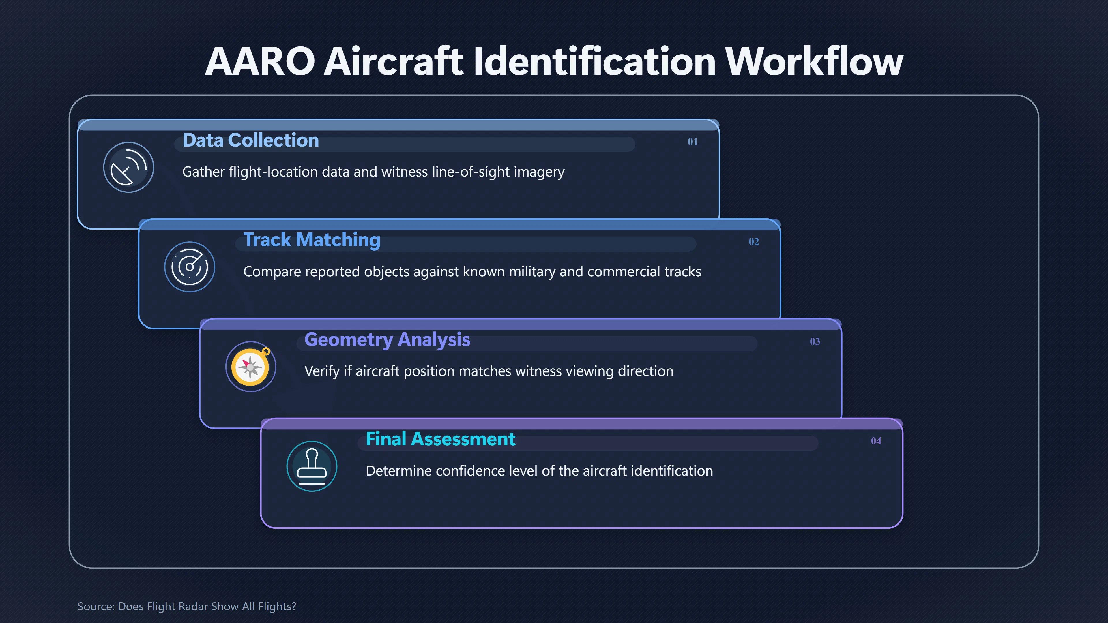
Flight-tracking data can be one of the strongest tools for reconstructing a UFO or UAP sighting. A recorded aircraft track supplies an independent timeline and can reveal position, altitude, speed and direction. When a particular aircraft occupies the witness’s line of sight at the right moment, it can turn a vague resemblance into a testable identification. The US All-domain Anomaly Resolution Office (AARO), for example, has matched reported objects to military and commercial aircraft by combining flight-location data with line-of-sight and imagery analysis.[AARO]aaro.milOpen source on aaro.mil.
The reverse inference is much weaker. Opening a public flight-tracking website, finding no aircraft at the reported position and concluding that there was therefore no aircraft is unsafe. Public trackers depend on aircraft transmitting suitable signals, receivers detecting them, networks preserving those observations and services choosing to display the resulting data. Gaps can arise at every stage. A blank map is therefore evidence about a particular dataset, not proof of an empty sky.[OpenSky Network]opensky-network.orgOpen source on opensky-network.org.
What aircraft broadcasts can reveal about a sighting
Automatic Dependent Surveillance–Broadcast (ADS-B) is especially useful because an equipped aircraft calculates its position using satellite navigation and broadcasts information that can include its position, altitude and velocity. Networks of ground receivers collect those radio transmissions and turn them into tracks. Flightradar24 says its network contains more than 50,000 ADS-B receivers, while the research-oriented OpenSky Network likewise collects broadcasts through receivers hosted by volunteers and institutional partners.[Flightradar24]flightradar24.comOpen source on flightradar24.com.
For UFO reconstruction, this turns an aircraft hypothesis into something considerably more precise than “there was a plane nearby”. Investigators can ask whether a candidate aircraft was actually where it needed to be at the observation time and whether its movement makes sense from the witness’s location. Altitude and position allow the aircraft’s approximate bearing and elevation to be reconstructed; successive positions reveal its apparent path. Those calculations can then be compared with a photograph, video, witness sketch or stated viewing direction.
The method is powerful precisely because proximity alone is not enough. In busy airspace there may be many aircraft within tens or even hundreds of kilometres. A convincing identification should fit the observation’s time and geometry rather than merely place an aircraft somewhere in the wider area.
AARO’s published analysis of three cases described as “atmospheric wakes” illustrates the distinction. In one case, aircraft-location data closely matched one reported object to a military aircraft, while a second object could not be matched in the same way and was assessed only with medium confidence as a small aircraft using line-of-sight comparisons. In another case, AARO’s partners identified a specific Airbus A380 using commercial flight data, with photogrammetry producing a size estimate consistent with that aircraft.[AARO]aaro.milOpen source on aaro.mil.
That is the evidential asymmetry investigators need to remember: finding the right track can strongly support an aircraft explanation; failing to find a track usually cannot strongly exclude one.
Why a missing flight track proves so little
A public flight map is not equivalent to an air-traffic controller’s complete surveillance picture. Several different mechanisms can make a genuine aircraft absent, partially recorded or impossible to identify.
Not every aircraft must broadcast ADS-B everywhere. In the United States, ADS-B Out requirements apply to specified classes and regions of airspace rather than every aircraft movement at every altitude and location. The rules also contain exceptions, including provisions affecting aircraft without engine-driven electrical systems and authorisations for aircraft that are not equipped with ADS-B Out.[Legal Information Institute]cornell.eduOpen source on cornell.edu.
The UK provides an equally useful warning against assuming universal electronic visibility. The Civil Aviation Authority says general-aviation aircraft that have no requirement to carry a transponder may use an electronic-conspicuity device voluntarily. More explicitly, its guidance on atypical air environments warns operators that general aviation can operate from suitable land without having to notify its activity or be electronically conspicuous.[Civil Aviation Authority]caa.co.ukOpen source on caa.co.uk. As of July 2026, the CAA is consulting on proposals that could make electronic conspicuity mandatory for civil aircraft below 10,000 feet — itself evidence that universal conspicuity is not yet the baseline.[Civil Aviation Authority]caa.co.ukOpen source on caa.co.uk.
Reception has physical limits. ADS-B broadcasts have to reach a receiver. FlightAware describes reception as essentially line-of-sight: high-altitude aircraft can be detected much farther away than aircraft near the ground. OpenSky similarly notes that an aircraft may disappear from its map simply because it is too low or no suitable sensor is nearby. Research on the OpenSky network has found that low-altitude coverage requires receivers relatively close to the aircraft because of these line-of-sight limitations.[flightaware.com]flightaware.comOpen source on flightaware.com.
This matters disproportionately for some plausible UFO misidentifications. A low helicopter, light aircraft or other local traffic may be visually prominent while being harder for a distant ground receiver to collect than an airliner cruising tens of thousands of feet overhead. Terrain, buildings, antenna placement and receiver density can further reduce coverage.[OpenSky Network]opensky-network.orgOpen source on opensky-network.org.
An aircraft may transmit Mode S without broadcasting its own ADS-B position. OpenSky explains that such an aircraft can be detected electronically without supplying the position required to draw an ordinary map track. Some networks can recover positions through multilateration, or MLAT, which estimates a transmitter’s position from the difference in arrival times at several receivers. But that requires sufficient receivers with appropriate geometry. FlightAware says its MLAT tracking of non-ADS-B aircraft requires proximity to four or more of its ground stations.[OpenSky Network]opensky-network.orgOpen source on opensky-network.org.
Consequently, “not on the map” can conceal several very different situations: no broadcast was made; a broadcast contained no directly usable position; too few receivers heard it; the network lacked coverage; or the service possessed information but did not make it public.
Why military and private traffic may be absent
Military, government and privacy-sensitive flights introduce another layer of uncertainty because absence can be deliberate rather than accidental.
US regulations normally require an ADS-B-equipped aircraft to transmit when the applicable rule requires it, but they expressly permit the FAA to authorise non-transmission during sensitive government missions involving national defence, homeland security, intelligence or law enforcement when broadcasting could compromise operational security or create a safety risk. That exception was introduced specifically because real-time ADS-B identification and position information could expose sensitive operations.[Legal Information Institute]cornell.eduOpen source on cornell.edu.
Even when an aircraft broadcasts, public presentation is a separate question. The FAA’s Limiting Aircraft Data Displayed (LADD) programme allows eligible owners or operators to restrict dissemination of their flight information through FAA feeds and participating internet tracking services. At its strongest setting, FAA-source filtering means the aircraft’s FAA flight data are unavailable to external vendors. Government, military and law-enforcement requests are handled through a separate security process.[Federal Aviation Administration]faa.govOpen source on faa.gov.
The FAA also operates the Privacy ICAO Address programme. Eligible aircraft can use a temporary alternate 24-bit ICAO address that is not associated with the owner in the public civil aircraft registry, making rapid identification through inexpensive receivers more difficult. Importantly, the FAA distinguishes this from LADD: LADD affects dissemination of FAA data, whereas the privacy address changes how readily a received ADS-B transmission can be tied to a particular aircraft.[Federal Aviation Administration]faa.govOpen source on faa.gov.
Commercial tracking services add their own presentation layer. FlightAware states that sensitive flights, including some military traffic, may not be publicly trackable and that private owners can have aircraft blocked. It also notes that people contributing receiver data may sometimes see information locally that is unavailable through its public service.[FlightAware]flightaware.comOpen source on flightaware.com.
These mechanisms should not be interpreted as evidence that every missing track represents a secret aircraft. They establish a narrower but important point: the public dataset is not complete enough for absence alone to eliminate aircraft as a hypothesis.
Different trackers can disagree
Checking several flight-tracking websites is better than checking one, but it does not automatically create several independent observations. Services may ingest overlapping receiver networks, government feeds or other common sources while applying different filtering and reconstruction rules.
The differences can nevertheless be diagnostically useful. One service may obtain ADS-B directly from volunteer receivers; another may combine terrestrial ADS-B with air-navigation or flight-plan information; another may retain raw Mode S messages for research. OpenSky, for example, archives raw received surveillance messages, while FlightAware describes using multiple data sources worldwide in addition to ADS-B.[OpenSky Network]opensky-network.orgOpen source on opensky-network.org.
Investigators should therefore distinguish three questions that are easily collapsed into one:
- Was the aircraft transmitting anything? A local radio receiver or raw surveillance archive may help answer this.
- Could the network determine its position? ADS-B supplies position directly, whereas a Mode S target may require MLAT or another surveillance source.
- Did the website display it publicly? Privacy, security and service-specific filtering can affect this independently of whether the aircraft was detected.
A disagreement between trackers can itself provide information. If one network shows a target while another does not, that points towards differences in coverage, data sources or filtering rather than an empty patch of airspace. If every public source is blank, the aircraft hypothesis becomes less directly supported — but the strength of that negative evidence still depends on whether the relevant location, altitude, aircraft type and operation should realistically have been visible to those systems.
How investigators strengthen weak public tracking records
The most defensible reconstruction treats a public flight track as one evidence layer rather than a universal aircraft census. When that layer is incomplete, investigators can test the aircraft hypothesis against other independent records.
A useful sequence is to begin with the exact observation window rather than a broad search around the reported date. Even an error of several minutes can put the wrong aircraft into the witness’s viewing direction. The witness location, camera direction and estimated elevation should then be used to compare candidate tracks geometrically, rather than ranking aircraft simply by geographic distance.
Investigators can strengthen or challenge the public record by combining:
- multiple flight-data sources, especially where they rely on meaningfully different receiver or surveillance inputs;
- raw or historical ADS-B and Mode S data, where available, rather than relying solely on a consumer map’s visual replay;
- MLAT-derived tracks for aircraft that transmitted Mode S but did not broadcast ADS-B positions;
- airport movements, flight plans and air-traffic records, where obtainable and appropriate;
- contemporaneous photographs, video and audio, including engine noise, navigation-light patterns and changes in apparent brightness as an aircraft turns;
- witness geometry, testing whether the proposed aircraft would have appeared at the reported bearing and elevation;
- other sensors or independent observers, particularly where they can constrain distance or direction.
This multi-source approach is not peculiar to UFO investigations. Modern research systems built specifically to study unusual aerial objects also use ADS-B as a reference rather than assuming it represents every object in the sky. The Galileo Project’s all-sky infrared camera work, for example, used ADS-B-equipped aircraft as a real-world calibration dataset while simultaneously reconstructing hundreds of thousands of optical trajectories. Its commissioning study emphasised the value of additional distance, kinematic and sensor information for resolving ambiguous detections.[PubMed]nih.govOpen source on nih.gov.

When aircraft should remain a live explanation
The correct conclusion from an empty public tracker is usually modest: no matching aircraft was found in the public tracking data examined. That statement is materially different from “there was no aircraft”.
How much weight the absence deserves depends on the circumstances. A missing track is more informative where coverage is known to have been excellent, the relevant aircraft would normally be ADS-B-equipped, several genuinely independent sources were checked, and the sighting geometry leaves little room for another flight path. It is substantially weaker for low-level traffic, poorly covered terrain, military or sensitive government operations, aircraft types not universally required to transmit suitable position data, or historical incidents for which detailed receiver records are unavailable.[cornell.edu]cornell.eduOpen source on cornell.edu.
Conversely, investigators should not rescue an aircraft hypothesis indefinitely by invoking hypothetical hidden traffic. Once available aviation records, viewing geometry, imagery and other evidence consistently contradict an aircraft explanation, its plausibility should fall. Missing public data justify uncertainty; they do not justify inventing an unseen aeroplane.
That distinction is central to responsible UFO reconstruction. Aircraft tracking is exceptionally valuable when it produces a positive, geometrically convincing match. Its blind spots become dangerous only when a public flight map is mistaken for a complete record of everything that flew. In an unresolved case, “no track found” describes a limitation of the evidence. It does not, by itself, describe what was or was not in the sky.
Amazon book picks
Further Reading
Books and field guides related to Why a Missing Flight Track Proves So Little. Use these as the next step if you want deeper reading beyond the article.
The UFO Experience: A Scientific Inquiry
Cited by the New York Review of Books as "the best brief for visitation," this classic study presents an analysis of UFO reports and conc...
Stick and Rudder: An Explanation of the Art of Flying
In the early 1940's, Wolfgang Langewiesche wrote a series of articles in Air Facts analyzing the various aspects of piloting techniques....
Weather Flying
Weather Flying is regarded in the industry as the bible of weather flying. Robert Buck, a general aviation and commercial pilot with tens...
The Thinking Pilot's Flight Manual: Or, How to Survive Flying...
Volume 2 of The Thinking Pilot's Flight Manual carries on the widely praise, penetrating, and clear-headed approach of Volume I, addressi...
eBay marketplace picks
Marketplace Samples
Live-tested eBay searches with available results related to this page.
Selected fromUFO poster oneBay.co.uk.

Current eBay listing
VINTAGE UFO FLYING SAUCERS COMIC ADVERTISING A2 POSTER PRINT


Current eBay listing
I Want To Believe UFO Poster Giclée Fine Art Heavyweight Print

Endnotes
1.
Source: aaro.mil
Link:https://www.aaro.mil/Portals/136/PDFs/case_resolution_reports/AARO_Puerto_Rico_UAP_Case_Resolution.pdf
2.
Source: aaro.mil
Link:https://www.aaro.mil/UAP-Records/
3.
Source: youtube.com
Title: Does Flight [Radar]({{ ‘radar/’ | relative_url }}) Show All Flights?
Link:https://www.youtube.com/watch?v=Amv4Ywjvz6g
Source snippet
Flightradar24 Tutorial: A Beginner's Guide to Tracking Flights...
4.
Source: youtube.com
Title: Flightradar24 Tutorial: A Beginner’s Guide to Tracking Flights
Link:https://www.youtube.com/watch?v=k7bJB0kv-PU
Source snippet
How To Track Any Aircraft (using Flightradar24)...
Additional References
5.
Source: youtube.com
Title: How To Track Any Aircraft (using Flightradar24)
Link:https://www.youtube.com/watch?v=THQKBMBEt40
Source snippet
Explaining ADS-B: why more receivers matter...
6.
Source: youtube.com
Title: Where Does Flightradar24 Get Its Plane Data?
Link:https://www.youtube.com/watch?v=ZHm7X4Fz0GA
Source snippet
Does Flight Radar Show All Flights?...
7.
Source: geipan.fr
Link:https://www.geipan.fr/en/what-did-i-see/step-1
8.
Source: youtube.com
Title: Explaining ADS-B: why more receivers matter
Link:https://www.youtube.com/watch?v=qVRwKlHoRWA