Within Tracking
What Go Fast's On Screen Data Reveals About Motion
Displayed range, angles, speed and bank data let analysts reconstruct the moving camera instead of judging speed by eye.
On this page
- Which flight and sensor values appear in the video
- How changing azimuth and elevation track camera motion
- What the telemetry changes about speed estimates
Page outline Jump by section
Introduction
The most useful evidence in the GoFast video is not the apparent rush of ocean beneath the tracked object. It is the numerical telemetry surrounding the image. The display records the F/A-18’s altitude and speed, the sensor’s azimuth and elevation, its range to the tracked target, elapsed time and the aircraft’s bank. Together, those values allow analysts to reconstruct how the aircraft and its steerable infrared camera were moving while the tracker kept the object near the centre of the picture.[NASA Science]science.nasa.govScience NASAUNIDENTIFIED ANOMALOUS PHENOMENA…
That reconstruction substantially changes the visual story. During a representative 13-second interval analysed by the US All-domain Anomaly Resolution Office (AARO), the F/A-18 travelled roughly 2.47 kilometres while banking through a turn. At the same time, the sensor swung farther left and downward to maintain its line of sight to the target. Once that moving viewpoint is included, the object’s apparent dash across the ocean no longer requires extraordinary speed.[AARO]aaro.milGo Fast Case ResolutionAARO GoFast Case Resolution…
Which flight and sensor values appear in GoFast?
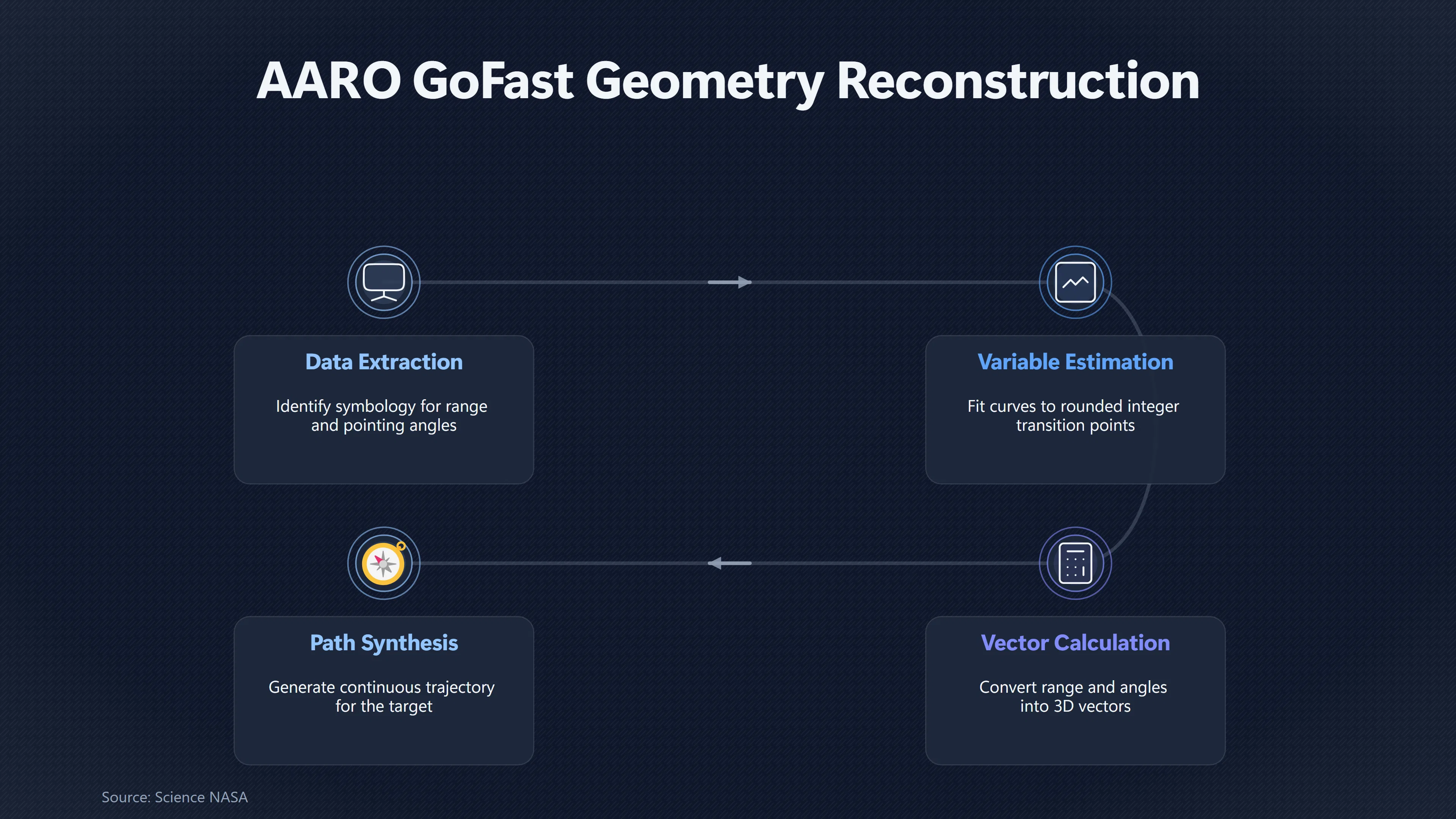
GoFast was recorded by an infrared sensor aboard a US Navy F/A-18F. Although AARO no longer had the original sensor file and associated metadata, it found that the symbology embedded in the publicly available video preserved enough information to reconstruct important parts of the observation geometry. The usable quantities include target range, sensor azimuth and elevation, aircraft altitude and speed, bank angle and relative frame timing.[AARO]aaro.milGo Fast Case ResolutionAARO GoFast Case Resolution…
NASA’s 2023 independent UAP study highlighted essentially the same point. Its GoFast analysis identified six particularly useful displayed quantities: camera elevation, camera azimuth, target range, aircraft altitude, time and indicated airspeed. NASA argued that these numbers provide a better basis for estimating the geometry than simply judging the apparent speed of the ocean background by eye.[NASA Science]science.nasa.govScience NASAUNIDENTIFIED ANOMALOUS PHENOMENA…
AARO subsequently developed a considerably more detailed reconstruction. It chose a 13-second interval, from display time 4239 to 4252 seconds, because the F/A-18’s altitude, bank and airspeed remained nearly constant. That reduces the number of changing variables that have to be estimated. During this interval:
- sensor azimuth changed from 49° left to 57° left;
- sensor elevation changed from −29° to −35°;
- displayed target range decreased from 4.0 to 3.4 nautical miles;
- aircraft altitude remained close to 25,000 feet;
- aircraft speed increased only slightly, from about Mach 0.61 to Mach 0.62; and
- the F/A-18 remained banked at approximately 14°.[UFO Transparency]ufotransparency.comUFO TransparencyAARO Website Launch: Go Fast Resolution, All-domain Anomaly Resolution Office (AARO), U.S. Department of Defense · 2023 ·…
Those numbers describe something the stabilised picture itself largely conceals: the viewing geometry was changing continuously. The target tracker kept the small object near the centre, but the sensor did not remain pointed in a fixed direction.
The changing angles reveal a sweeping camera
The clearest indication of camera motion is the changing azimuth. At the beginning of AARO’s selected interval the sensor was looking 49° to the aircraft’s left; 13 seconds later it was looking 57° left. Its line of sight therefore swept another eight degrees sideways relative to the aircraft while maintaining track. Simultaneously, the elevation changed from 29° below the aircraft’s reference direction to 35° below it.[AARO]aaro.milGo Fast Case ResolutionAARO GoFast Case Resolution…
That is exactly the information missing from an intuitive reading of the image. Because the tracking system holds the target close to the middle of the display, the viewer does not watch the target race normally from one edge of the frame to the other. Instead, the camera rotates to follow it. The visible consequence is that the distant ocean sweeps across the field of view.
The aircraft itself was also changing direction. Using the roughly 14° bank and an average speed of about 190 metres per second, AARO calculated a turn radius of approximately 14.76 kilometres. Over 13 seconds the F/A-18 covered about 2,470 metres along that curved path and changed heading by approximately 9.6°. Its reconstructed displacement was about 2,461 metres forwards and 207 metres sideways relative to its starting coordinate system.[AARO]aaro.milGo Fast Case ResolutionAARO GoFast Case Resolution…
So there were two coupled motions that a viewer has to recover: the aircraft was rapidly translating and turning, while the sensor was simultaneously rotating relative to that aircraft. The apparently stable central object hides much of the second motion, while the moving ocean visually exaggerates its importance.
AARO converted the displayed range and pointing angles into three-dimensional line-of-sight vectors. At its first analysed point, for example, a 4.0-nautical-mile range combined with −29° elevation and 49°-left azimuth placed the target roughly 4,251 metres ahead, 4,890 metres to the left and 3,591 metres below the aircraft in AARO’s aircraft-relative coordinate system. Given an aircraft altitude near 25,000 feet, that calculation put the target at about 13,219 feet, nowhere near the sea surface.[AARO]aaro.milGo Fast Case ResolutionAARO GoFast Case Resolution…
At the second point, the same procedure incorporated the aircraft’s newly calculated position and heading as well as the changed sensor angles and range. The resulting target altitude was approximately 13,150 feet. The close agreement between the two independently reconstructed positions indicates a target travelling roughly level rather than an object skimming just above the ocean.[AARO]aaro.milGo Fast Case ResolutionAARO GoFast Case Resolution…
That altitude matters enormously for visual interpretation. The ocean seen behind the object is several kilometres farther away. It is therefore a background reference plane rather than a surface that the object can safely be assumed to be flying immediately above.
Telemetry turns apparent motion into geometry
The reconstruction can be thought of as a moving triangle. At each instant, one point is the F/A-18, another is the target and the sensor’s measured range and pointing direction connect the two. Move the aircraft forwards, rotate it according to its bank-induced turn, rotate the sensor according to its displayed azimuth and elevation, and the target’s new relative position can be calculated.
AARO first performed this calculation using the two endpoints. It found that the reconstructed target positions were only about 265 metres apart over 13 seconds, corresponding to roughly 20 metres per second, or 45 mph, in the no-wind aircraft-relative model. Its calculated direction was broadly similar to the F/A-18’s direction but the target was moving about nine times more slowly.[AARO]aaro.milGo Fast Case ResolutionAARO GoFast Case Resolution…
AARO then went beyond the endpoint calculation. Because the display reports several quantities only as rounded integers, simply reading individual frames discards information. The analysts therefore recorded the frames at which azimuth, elevation and range changed from one displayed integer to the next, then fitted curves through those transition points to estimate intermediate values. Applying the reconstruction frame by frame produced a continuous target path.[AARO]aaro.milGo Fast Case ResolutionAARO GoFast Case Resolution…
That refined no-wind calculation gave a displacement of about 226 metres in 13 seconds, equivalent to approximately 38.9 mph. The reconstructed trajectory was relatively straight and approximately level; AARO cautioned that small bends near the end were more likely residual error in its estimated aircraft path than evidence of a real manoeuvre.[AARO]aaro.milGo Fast Case ResolutionAARO GoFast Case Resolution…
This result is strikingly close to NASA’s earlier, simpler treatment. NASA used the displayed geometry over a somewhat longer 22-second interval and estimated that the target moved about 390 metres, giving an average speed of approximately 40 mph. NASA explicitly noted that its calculation neglected wind effects on the aircraft and therefore should not be treated as a precise final velocity.[NASA Science]science.nasa.govScience NASAUNIDENTIFIED ANOMALOUS PHENOMENA…
The agreement does not mean that GoFast’s speed is known to be exactly 40 mph. It means that two analyses of the on-screen telemetry demonstrate the more important point: the footage does not require the extraordinary velocity suggested by its visual appearance.
Why AARO gives a speed range rather than one number
There is an important limitation to the reconstruction. The display does not provide the F/A-18’s absolute geographical position or compass heading, and AARO did not possess the original sensor metadata. Consequently, the aircraft’s path can be reconstructed relative to its starting orientation, but it cannot simply be placed on a map with a known north-south heading.[AARO]aaro.milGo Fast Case ResolutionAARO GoFast Case Resolution…
That becomes important when wind is included. Airspeed tells analysts how the F/A-18 is moving through the surrounding air, not its exact velocity over the ground. AARO therefore used historical atmospheric data near the reported time and location. It found winds of about 60 knots (69 mph) at 13,000 feet and about 101 knots (116 mph) at 25,000 feet. Because the aircraft’s exact heading relative to those winds was unavailable, AARO tested the full range of possible orientations rather than choosing one favourable geometry.[AARO]aaro.milGo Fast Case ResolutionAARO GoFast Case Resolution…
Across those possibilities, AARO calculated an object’s ground-relative speed of roughly 72 to 161 mph depending on geometry. After subtracting the contribution of the wind at the object’s altitude, its estimated intrinsic speed ranged from about 5 to 92 mph. In AARO’s simulations, its heading never differed from the wind direction by more than about 32°, and it never travelled against the wind.[AARO]aaro.milGo Fast Case ResolutionAARO GoFast Case Resolution…
This explains why apparently conflicting figures such as NASA’s roughly 40 mph estimate, AARO’s roughly 39–46 mph no-wind reconstruction and AARO’s broader 5–92 mph wind-compensated range should not simply be treated as rival claims. They answer somewhat different versions of the geometry problem and make different allowances for information that is missing from the released recording. The robust finding shared by them is narrower: nothing in the displayed telemetry demands an exceptionally fast object.[nasa.gov]science.nasa.govScience NASAUNIDENTIFIED ANOMALOUS PHENOMENA…
What the telemetry changes about the GoFast impression
Watching GoFast without using its instrumentation encourages an understandable but unsupported inference: the target looks close to the sea, the sea races past it, therefore the target itself must be racing over the water. The telemetry breaks that chain.
First, range, elevation and aircraft altitude place the object at roughly 13,000 feet, meaning that it is separated vertically from the ocean by about 2.5 miles. NASA independently obtained the same approximate altitude from the displayed quantities.[AARO]aaro.milGo Fast Case ResolutionAARO GoFast Case Resolution…
Second, the aircraft carrying the sensor was itself moving at roughly 190 metres per second — about 425 mph — during AARO’s analysed interval. It therefore shifted its viewpoint by kilometres during only a few seconds of footage.[UFO Transparency]ufotransparency.comUFO TransparencyAARO Website Launch: Go Fast Resolution, All-domain Anomaly Resolution Office (AARO), U.S. Department of Defense · 2023 ·…
Third, the camera’s own telemetry shows that its line of sight was sweeping while tracking the object. The azimuth moved from 49° to 57° left and the elevation from −29° to −35° in AARO’s 13-second window. What looks on screen like an object staying conveniently fixed while the ocean races behind it is therefore not a static-camera observation. It is the output of an actively redirected sensor aboard a fast, turning aircraft.[AARO]aaro.milGo Fast Case ResolutionAARO GoFast Case Resolution…
This is why AARO attributes the dramatic apparent speed principally to motion parallax: rapid displacement of the observer changes the angular relationship between a nearer target and the much more distant background. Target tracking makes that effect particularly counter-intuitive because the sensor continually compensates for the target’s image motion, leaving the background to carry much of the visible movement.[AARO]aaro.milGo Fast Case ResolutionAARO GoFast Case Resolution…
The telemetry does not identify what the GoFast object was. AARO explicitly says it cannot make a definitive identification, and its reconstruction is constrained by the loss of the original file, missing absolute aircraft position and heading, rounded display values and the absence of obtainable aircrew witness accounts in its investigation.[AARO]aaro.milGo Fast Case ResolutionAARO GoFast Case Resolution…
What the on-screen data can address much more directly is the narrower performance claim. GoFast is a particularly instructive UFO/UAP case because the same recording that creates the impression of extraordinary motion also contains the measurements needed to test that impression. Once the aircraft’s kilometre-scale movement, its bank-induced turn, the sensor’s changing azimuth and elevation, the measured target range and the winds aloft are put back into the geometry, the apparently spectacular dash over the ocean is compatible with an object moving at ordinary speeds.[AARO]aaro.milGo Fast Case ResolutionAARO GoFast Case Resolution…

Amazon book picks
Further Reading
Books and field guides related to What Go Fast's On Screen Data Reveals About Motion. Use these as the next step if you want deeper reading beyond the article.
Flight Dynamics Principles
Flight dynamicists today need not only a thorough understanding of the classical stability and control theory of aircraft, but also a wor...
Multiple View Geometry in Computer Vision
A basic problem in computer vision is to understand the structure of a real world scene given several images of it. Techniques for solvin...
Aircraft Control and Simulation
This second edition covers aerodynamics, the control systems and the mathematics involved in analysing the performance of aircraft not on...
Computer Vision: Algorithms and Applications
Computer Vision: Algorithms and Applications explores the variety of techniques used to analyze and interpret images. It also describes c...
eBay marketplace picks
Marketplace Samples
Live-tested eBay searches with available results related to this page.
Selected fromUFO poster oneBay.co.uk.

Current eBay listing
I Want To Believe UFO Poster Giclée Fine Art Heavyweight Print


Current eBay listing
VINTAGE UFO FLYING SAUCERS COMIC ADVERTISING A2 POSTER PRINT

Endnotes
1.
Source: science.nasa.gov
Title: Science NASA
Link:https://science.nasa.gov/wp-content/uploads/2023/09/uap-independent-study-team-final-report.pdf
Source snippet
UNIDENTIFIED ANOMALOUS PHENOMENA...
2.
Source: aaro.mil
Title: [Go Fast]({{ ‘go-fast/’ | relative_url }}) Case Resolution
Link:https://www.aaro.mil/Portals/136/PDFs/case_resolution_reports/AARO_GoFast_Case_Resolution_Card_Methodology_Final.pdf?ver=qXvjrruO_0MgtnTsfYnCEQ%3D%3D
Source snippet
AARO GoFast Case Resolution...
3.
Source: science.nasa.gov
Title: gtn sag
Link:https://science.nasa.gov/astrophysics/programs/physics-of-the-cosmos/community/gtn-sag/
Source snippet
Ray Transient Network Science Analysis Group (GTN SAG) - NASA ScienceJune 3, 2026 — Physics of the Cosmos SCIENCE ANALYSIS GROUP GAMMA RA...
Published: June 3, 2026
4.
Source: science.nasa.gov
Link:https://science.nasa.gov/technology/resources/
5.
Source: aaro.mil
Link:https://www.aaro.mil/Next-AARO-Home-redesign/Next-Parent/Next-AARO-UAP-Imagery-Acc-Table/
6.
Source: aaro.mil
Link:https://www.aaro.mil/Next-AARO-Home-redesign/Next-Parent/Next-UAP-Report-Documents/poster/dividLink/
7.
Source: science.nasa.gov
Link:https://science.nasa.gov/uap/faqs/
8.
Source: science.nasa.gov
Link:https://science.nasa.gov/about-us/ocsdo/reports/
9.
Source: science.nasa.gov
Title: inter calibration
Link:https://science.nasa.gov/mission/clarreo-pathfinder/inter-calibration/
10.
Source: fireballs.ndc.nasa.gov
Link:https://fireballs.ndc.nasa.gov/skyfalls/events/20260317-125642?linkId=920502932
11.
Source: science.nasa.gov
Link:https://science.nasa.gov/universe/glossary/
12.
Source: science.nasa.gov
Link:https://science.nasa.gov/uap/
13.
Source: nasa.gov
Title: X-43A Hyper-X
Link:https://www.nasa.gov/reference/x-43a/
14.
Source: nasa.gov
Title: Scientific Balloon FAQs
Link:https://www.nasa.gov/scientificballoons/faqs/
15.
Source: science.nasa.gov
Title: impact reports
Link:https://science.nasa.gov/learn/impact-reports/
16.
Source: science.nasa.gov
Link:https://science.nasa.gov/learn/basics-of-space-flight/glossary/
17.
Source: science.nasa.gov
Title: nasem reports corresponding nasa letters
Link:https://science.nasa.gov/researchers/nasem-reports-corresponding-nasa-letters/
18.
Source: science.nasa.gov
Title: ice mapper measurement definition team
Link:https://science.nasa.gov/researchers/ice-mapper-measurement-definition-team
19.
Source: science.nasa.gov
Link:https://science.nasa.gov/resource/guidance-navigation-and-control-technology-assessment-for-future-planetary-science-missions-part-ii-onboard-guidance-navigation-and-control-gnc/
20.
Source: science.nasa.gov
Link:https://science.nasa.gov/resource/guidance-navigation-and-control-technology-assessment-for-future-planetary-science-missions-part-iv-aerial-guidance-navigation-and-control/
21.
Source: science.nasa.gov
Title: independent review board makes recommendations for gdc
Link:https://science.nasa.gov/blogs/gdc/2022/10/12/independent-review-board-makes-recommendations-for-gdc/
22.
Source: grc.nasa.gov
Link:https://www.grc.nasa.gov/www/k-12/WindTunnel/Activities/knot508.html
23.
Source: grc.nasa.gov
Link:https://www.grc.nasa.gov/www/k-12/airplane/airsimu.html
24.
Source: grc.nasa.gov
Link:https://www.grc.nasa.gov/WWW/k-12/airplane/mach.html
25.
Source: grc.nasa.gov
Title: lift formula
Link:https://www.grc.nasa.gov/www/k-12/WindTunnel/Activities/lift_formula.html
26.
Source: grc.nasa.gov
Title: knots vs mph
Link:https://www.grc.nasa.gov/www/k-12/WindTunnel/Activities/knots_vs_mph.html
27.
Source: science.nasa.gov
Title: nasa gravitational wave electromagnetic counterpart task force 2019
Link:https://science.nasa.gov/astrophysics/programs/physics-of-the-cosmos/studies/nasa-gravitational-wave-electromagnetic-counterpart-task-force-2019/
28.
Source: science.nasa.gov
Title: science advice to nasa conflict consensus partnership leadership
Link:https://science.nasa.gov/resource/science-advice-to-nasa-conflict-consensus-partnership-leadership/
29.
Source: science.nasa.gov
Title: altitude 137 miles speed 14209 mph
Link:https://science.nasa.gov/blogs/goes/2016/11/19/altitude-137-miles-speed-14209-mph/
30.
Source: nasa.gov
Title: Fireball Lights Pre-Dawn Sky over Arizona
Link:https://www.nasa.gov/centers-and-facilities/marshall/fireball-lights-pre-dawn-sky-over-arizona/
31.
Source: science.nasa.gov
Title: the heights of mount sharp
Link:https://science.nasa.gov/resource/the-heights-of-mount-sharp/
32.
Source: science.nasa.gov
Title: weather stations lidar in action
Link:https://science.nasa.gov/photojournal/weather-stations-lidar-in-action/
33.
Source: science.nasa.gov
Title: mars pathfinder filled donut mosaic
Link:https://science.nasa.gov/photojournal/mars-pathfinder-filled-donut-mosaic
34.
Source: science.nasa.gov
Title: mars pathfinder rover traverse image
Link:https://science.nasa.gov/resource/mars-pathfinder-rover-traverse-image/
35.
Source: science.nasa.gov
Title: mars pathfinder rover traverse image
Link:https://science.nasa.gov/photojournal/mars-pathfinder-rover-traverse-image/
36.
Source: science.nasa.gov
Title: topographic map of pathfinder landing site
Link:https://science.nasa.gov/resource/topographic-map-of-pathfinder-landing-site
37.
Source: science.nasa.gov
Title: topographic map of pathfinder landing site
Link:https://science.nasa.gov/photojournal/topographic-map-of-pathfinder-landing-site/
38.
Source: aaro.mil
Link:https://www.aaro.mil/Next-AARO-Home-redesign/Next-Parent/Next-AARO-UAP-Imagery-Fixed-Table/
39.
Source: aaro.mil
Link:https://www.aaro.mil/UAP-Cases/Official-UAP-Imagery/ftag/MSF0951a18/
40.
Source: aaro.mil
Link:https://www.aaro.mil/Next-AARO-Home-redesign/Next-Parent/Next-UAP-Case-RR-Data-Table/
41.
Source: aaro.mil
Link:https://www.aaro.mil/UAP-Cases/Official-UAP-Imagery/4/
42.
Source: aaro.mil
Link:https://www.aaro.mil/Next-AARO-Home-redesign/Next-Parent/AARO-UAP-Case-Resolution-DT/
43.
Source: aaro.mil
Title: UAP Imagery* “Go Fast” Object NAVAIR
Link:https://www.aaro.mil/Next-AARO-Home-redesign/Inactive-Parent/Next-UAP-Imagery-dup/
44.
Source: svs.gsfc.nasa.gov
Title: script 23617 00
Link:https://svs.gsfc.nasa.gov/vis/a010000/a014100/a014142/script_23617_00.html
45.
Source: grc.nasa.gov
Link:https://www.grc.nasa.gov/WWW/k-12/VirtualAero/BottleRocket/airplane/sound.html
46.
Source: ufotransparency.com
Link:https://ufotransparency.com/files/decade-2020s-aaro-website-launch-case-resolutions-2023-aaro-gofast-case-resolution-card-methodology-
Source snippet
UFO TransparencyAARO Website Launch: Go Fast Resolution, All-domain Anomaly Resolution Office (AARO), U.S. Department of Defense · 2023 ·...
47.
Source: ufotransparency.com
Link:https://ufotransparency.com/files/decade-2020s-aaro-gofast-case-resolution-2025-aaro-gofast-case-resolution-card-methodology-final
48.
Source: ufotransparency.com
Link:https://ufotransparency.com/files/2024-11-19-aaro-sasc-case-slides-aaro-sasc-case-slides
49.
Source: iufodb.com
Link:https://www.iufodb.com/gofast/
50.
Source: ufotransparency.com
Link:https://ufotransparency.com/files/2024-02-26-aaro-western-united-states-uap-case-resolution-aaro-western-us-case-resolution
51.
Source: ufotransparency.com
Link:https://ufotransparency.com/files/decade-2020s-nasa-uap-independent-study-report-2023-uap-independent-study-team-final-report
52.
Source: ufotransparency.com
Title: decade 2020s dod navy video official release 2020 gofast
Link:https://ufotransparency.com/files/decade-2020s-dod-navy-video-official-release-2020-gofast
53.
Source: ufotransparency.com
Link:https://ufotransparency.com/topics/aaro-case-resolutions
54.
Source: ufotransparency.com
Link:https://ufotransparency.com/takeaways/all
55.
Source: ufotransparency.com
Title: decade 2020s
Link:https://ufotransparency.com/findings/decade-2020s
56.
Source: docs.senseaeronautics.com
Link:https://docs.senseaeronautics.com/endpoints/output/
Additional References
57.
Source: legalclarity.org
Title: navy uap key encounters hearings and disclosure
Link:https://legalclarity.org/navy-uap-key-encounters-hearings-and-disclosure/
Source snippet
Navy UAP: Key Encounters, Hearings, and Disclosure - LegalClarityJuly 2, 2026 — CASE RESOLUTIONS AND OFFICIAL FINDINGS AARO has published...
Published: July 2, 2026
58.
Source: aatip.com
Title: UAP Case Files & Official Reports | AATIP.com
Link:https://www.aatip.com/inpage/case-files/
Source snippet
Eight widely discussed incidents, checked against official imagery, resolution reports and primary government records. What was reported...
59.
Source: uaplogbook.com
Title: Which UAP cases remain unexplained?
Link:https://uaplogbook.com/uap-evidence-ledger-unresolved-cases/
Source snippet
A 2026 evidence ledgerJuly 22, 2026 — GOFAST is the clearest example of a claim that can be narrowed substantially from the public record...
Published: July 22, 2026
60.
Source: youtube.com
Title: Explained: “Go Fast” UFO Video
Link:https://www.youtube.com/watch?v=PLyEO0jNt6M
Source snippet
Pentagon claims to debunk famous 'GOFAST' UFO [radar]({{ 'radar/' | relative_url }}) video, but still has not ID'd mysterious object...
61.
Source: youtube.com
Title: The SHOCKING Math Error Behind Viral UFO Videos | Mick West
Link:https://www.youtube.com/watch?v=ypfbhfEXnBo
Source snippet
Explained: "Go Fast" UFO Video - Not Low and Not Fast - Like a Balloon...
62.
Source: youtube.com
Title: Quantum physicists analyze pentagon US navy UFO video footage
Link:https://www.youtube.com/watch?v=cwACSrLEPeM
Source snippet
Mick West GoFast telemetry numbers Explained: New Navy UFO Videos...
63.
Source: youtube.com
Link:https://www.youtube.com/watch?v=fh3znHctOkA
Source snippet
Explained: New Navy UFO Videos...
64.
Source: metabunk.org
Link:https://www.metabunk.org/threads/go-fast-footage-from-tom-delonges-to-the-stars-academy-bird-balloon.9569/page-14
65.
Source: metabunk.org
Link:https://www.metabunk.org/threads/go-fast-footage-from-tom-delonges-to-the-stars-academy-bird-balloon.9569/page-15
66.
Source: metabunk.org
Link:https://www.metabunk.org/threads/go-fast-footage-from-tom-delonges-to-the-stars-academy-bird-balloon.9569/page-6