Within Field of View
Why the Background Can Exaggerate UFO Travel
Projecting a nearer UFO's motion onto distant ocean or terrain can make its apparent path far longer than the distance it actually travels.
On this page
- How a line of sight paints motion onto distant scenery
- Why target and background distance matter
- How projected paths can overstate physical displacement
Page outline Jump by section
Introduction
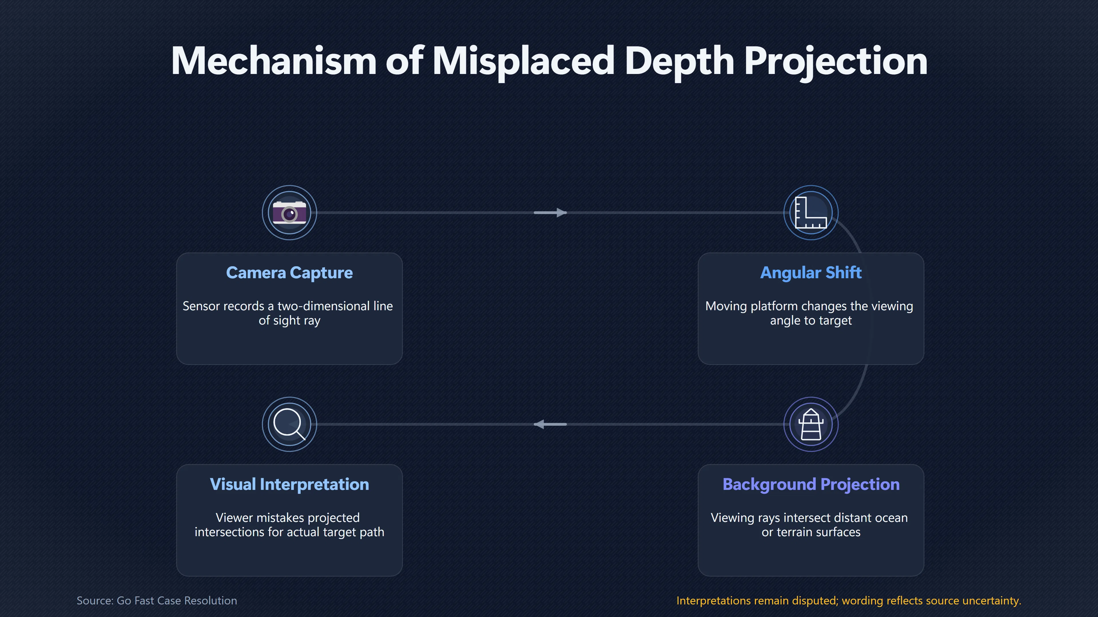
A UFO or UAP seen against distant ocean or terrain can appear to travel much farther than it actually does. The reason is geometric: a camera records a line of sight, not a ready-made three-dimensional flight path. If a nearer object is visually treated as though it lies on the distant background, its changing viewing direction can be projected onto that background, creating an apparent path that is substantially longer than the object’s real displacement.
This is especially deceptive in narrow-field, tracking-camera footage. The target may stay near the centre while the sea or terrain moves behind it, encouraging the eye to interpret the object as skimming across that surface. The Pentagon’s All-domain Anomaly Resolution Office (AARO) explicitly demonstrated this mechanism in its detailed analysis of the Navy’s “Go Fast” UAP video: the object’s start and end positions, when projected down to the ocean, produced a longer apparent journey than the object’s calculated path at altitude.[AARO]aaro.milGo Fast Case ResolutionAARO GoFast Case Resolution…
How a line of sight paints motion onto distant scenery
Every image point corresponds to a ray extending outward from the camera. Perspective geometry alone does not tell the viewer where along that ray an object sits. This is a basic limitation of monocular imaging: in photogrammetry, the camera centre, image point and corresponding point in the outside world lie on the same projection line, while scale along that line cannot generally be recovered from one photograph alone.[PubMed Central (PMC)]pmc.ncbi.nlm.nih.govPubMed Central (PMC)Interpretation and Transformation of Intrinsic Camera Parameters Used in Photogrammetry and Computer Vision - PMCDece…
That matters when interpreting UAP footage. Imagine an airborne camera looking down towards the sea. A target is suspended several kilometres above the water. As the aircraft and target move, the viewing ray to the target changes direction. Extend each of those rays beyond the target until it intersects the sea surface and the intersections will also move.
Those intersections are not the target’s positions. They are simply the places on the background that happen to lie behind the target from the camera’s changing viewpoint. Yet visually they can be compelling: if the viewer assumes the target is close to the water, the changing intersections resemble a real path over the sea.
AARO’s Go Fast methodology illustrates precisely this distinction. Its analysis describes the target’s starting and stopping positions projected onto the ocean surface and compares the distance between those projected points with the object’s actual calculated displacement at about 13,000 feet. AARO says the longer projected distance contributes directly to the impression of unusually high speed.[AARO]aaro.milGo Fast Case ResolutionAARO GoFast Case Resolution…
This is therefore more specific than simply saying that “parallax makes things look fast”. The important mechanism is misplaced depth: motion occurring at one distance is mentally or analytically assigned to a surface at another distance.
Why target and background distance matter
The same angular change corresponds to different physical distances depending on how far from the observer it is placed. That is why angular motion visible in a video cannot by itself establish how many metres or kilometres a target has travelled.
A simple thought experiment makes the problem clearer. Suppose two sightlines differ by a small angle. At a nearby range, the points on those rays are relatively close together. Extend the same rays much farther away and their separation grows. Consequently, treating an airborne object’s angular displacement as movement across a much more distant ground or ocean surface can magnify the inferred physical displacement.
Remote-sensing practice handles this problem by explicitly reconstructing viewing geometry. NASA Earth-observation geolocation products, for example, use line-of-sight vectors together with spacecraft ephemeris, attitude, sensor geometry, an Earth model and terrain elevation to determine where image pixels actually correspond to locations on the surface.[NASA Earthdata]earthdata.nasa.govNASA EarthdataVIIRS/JPSS2 Day/Night Band Resolution Terrain Corrected Geolocation 6-Min L1 Swath 750m NRT | NASA EarthdataJanuary 9, 2024… USGS descriptions of satellite triangulation likewise distinguish the sensor’s line-of-sight vectors from the ground points derived from those vectors.[USGS]usgs.govSpace-based triangulation procedure | U.S. Geological SurveySpace-based triangulation procedure | U.S. Geological SurveyJuly 10, 2019…
A UAP video viewer usually has nothing comparable. A small target against largely featureless water supplies almost no intuitive depth information. If it looks sharp and visually adjacent to the ocean, the natural interpretation may be that it is low over the surface. But visual adjacency in a two-dimensional frame does not establish physical proximity in three dimensions.
That distinction becomes particularly important at shallow viewing angles and long background distances. Perspective causes world distances represented near a distant part of the scene to behave very differently from distances close to the camera. In machine-vision geometry, recovering ground position from an image requires information about camera height, orientation and projection; errors become increasingly consequential where perspective compresses distant scenery.[PubMed Central (PMC)]pmc.ncbi.nlm.nih.govPubMed Central (PMC)Interpretation and Transformation of Intrinsic Camera Parameters Used in Photogrammetry and Computer Vision - PMCDece…
Go Fast shows the projection problem directly
The Navy’s Go Fast footage is unusually useful because its display contains enough numerical information to test the visual impression. The video appears at first glance to show a small object racing just above the Atlantic. NASA’s 2023 UAP independent study instead used the displayed range, viewing angle and aircraft altitude to calculate that the object was roughly 13,000 feet above sea level, leaving several kilometres of vertical separation between it and the ocean visible behind it. NASA concluded that the sensor platform’s high speed and parallax contributed substantially to the impression of rapid movement.[NASA Science]science.nasa.govScience NASAUNIDENTIFIED ANOMALOUS PHENOMENA…
NASA’s reconstruction estimated that during a 22-second interval the object travelled about 390 metres, corresponding to roughly 40 mph (64 km/h). The report cautioned that its calculation neglected wind effects on the aircraft, so the number carried uncertainty; its important conclusion was that extraordinary speed was not required to reproduce the observation.[Wikisource]en.wikisource.orgNASA Unidentified Anomalous Phenomena: Independent Study Team Report/Work Products: Discussion - Wikisource, the free online li…
AARO subsequently conducted a more extensive reconstruction. Its February 2025 case resolution assessed the object’s altitude at approximately 13,000 feet with high confidence. Because the aircraft’s exact compass heading was unavailable, AARO modelled possible headings and historical winds rather than claiming one uniquely determined target speed. It ultimately assessed that the object’s wind-compensated speed fell between about 5 and 92 mph across the modelled cases and that the footage demonstrated no anomalous performance.[AARO]aaro.milGo Fast Case ResolutionAARO GoFast Case Resolution…
More important for the background-projection mechanism is AARO’s final visualisation. It separately represented the object’s real calculated movement at altitude and the much longer movement obtained by projecting its sightlines onto the surface. AARO explicitly states that the greater projected distance relative to the actual distance is what produces the perceived high speed. Under one modelled headwind geometry, the effect becomes still stronger.[AARO]aaro.milGo Fast Case ResolutionAARO GoFast Case Resolution…
The case therefore provides a concrete warning against reading the apparent path over the ocean as though it were a measured ground track.

Projected paths are not physical flight paths
There are three different quantities that can easily be conflated when watching this kind of footage:
- Image displacement is how a target or background moves across the two-dimensional sensor frame.
- Projected surface displacement is the distance between places where successive lines of sight intersect an assumed surface such as the ocean.
- Physical target displacement is the distance between the object’s actual three-dimensional positions.
Only the third directly describes how far the object travelled. Converting the first into the third requires range and viewing geometry. Converting the first into the second and then treating that result as target movement silently assumes that the object lies on, or very close to, the chosen background surface.
Go Fast demonstrates how large the resulting conceptual error can be. AARO’s no-wind reconstruction calculated about 226 metres of target displacement during the analysed 13-second continuous path, with an estimated speed of about 38.9 mph. Once winds and possible aircraft headings were included, the reconstructed target distance varied substantially, from roughly 426 to 929 metres in four representative scenarios.[AARO]aaro.milGo Fast Case ResolutionAARO GoFast Case Resolution… These figures describe modelled motion at the object’s altitude; the conspicuous sweep across the ocean in the video is not itself a measurement of any of those distances.
This also explains why simply timing how long a UFO appears to take to cross a patch of distant terrain can produce an impressive but invalid speed estimate. If the assumed terrain distance is wrong because the object is actually much nearer to the camera, both the inferred distance and the resulting speed can be exaggerated.
What investigators need before claiming a long traverse
The strongest safeguard is an independent measurement of target range. If range is known at successive times, analysts can combine it with sensor pointing angles and platform position to reconstruct three-dimensional locations instead of assigning the target to the visible background.
Go Fast again shows the value of that information. AARO reported that the public video supplied range to target, camera azimuth and elevation, aircraft altitude, speed and bank angle. Those measurements were sufficient to constrain the object’s altitude and motion even though the original file, complete metadata, exact aircraft position and heading were unavailable. AARO nevertheless emphasised that these missing data limited the precision of its reconstruction.[AARO]aaro.milGo Fast Case ResolutionAARO GoFast Case Resolution…
Where reliable range is absent, apparent ground travel should therefore be treated cautiously. Useful evidence can include multiple calibrated viewpoints, radar range, laser ranging, accurate platform position and attitude, or identifiable terrain combined with sufficiently constrained camera geometry. NASA’s broader UAP study similarly stressed that the limited quantity of high-quality observations makes firm scientific conclusions difficult and advocated better calibrated, well-characterised data collection.[NASA Science]science.nasa.govScience UAPScience UAP
The key question is not simply “How far does the object seem to cross the background?” It is “At what distance from the sensor was the object while that angular motion occurred?” Until that depth is constrained, a dramatic-looking traverse over ocean or terrain may be a projection of the sightline rather than a measurement of the UFO’s physical journey.
The practical takeaway
Background scenery can give UAP footage an intuitively convincing but false ruler. A distant coastline, cloud deck or ocean surface appears to provide scale, yet it provides valid scale for the target only if the target’s relationship to that background is actually known.
That is why narrow-field footage deserves particular care. The cropped view can remove the wider spatial cues that would expose the separation between target and background, while tracking keeps the object visually stable and lets distant scenery stream past it. Once the eye interprets the object as travelling over that scenery, the projected path can be mistaken for a real one.
AARO’s Go Fast reconstruction turns this from a hypothetical optical warning into a documented UAP-analysis example: the office explicitly distinguishes the longer surface-projected path from the shorter calculated path at altitude.[AARO]aaro.milGo Fast Case ResolutionAARO GoFast Case Resolution… The broader lesson is narrow but important. Before an apparent UFO traverse is converted into kilometres travelled, and kilometres travelled into extraordinary speed, investigators must establish where the object actually sits along the line of sight.
Amazon book picks
Further Reading
Books and field guides related to Why the Background Can Exaggerate UFO Travel. Use these as the next step if you want deeper reading beyond the article.
Multiple View Geometry in Computer Vision
A basic problem in computer vision is to understand the structure of a real world scene given several images of it. Techniques for solvin...
Computer Vision: Algorithms and Applications
Computer Vision: Algorithms and Applications explores the variety of techniques used to analyze and interpret images. It also describes c...
An Invitation to 3-D Vision: From Images to Geometric Models
This book is intended to give students at the advanced undergraduate or introduc tory graduate level, and researchers in computer vision,...
The Geometry of Multiple Images
This book formalizes and analyzes the relations between multiple views of a scene from the perspective of various types of geometries. A...
eBay marketplace picks
Marketplace Samples
Live-tested eBay searches with available results related to this page.
Selected fromUFO poster oneBay.co.uk.



Current eBay listing
VINTAGE UFO FLYING SAUCERS COMIC ADVERTISING A2 POSTER PRINT

Current eBay listing
I Want To Believe UFO Poster Giclée Fine Art Heavyweight Print
Endnotes
1.
Source: aaro.mil
Title: Go Fast Case Resolution
Link:https://www.aaro.mil/Portals/136/PDFs/case_resolution_reports/AARO_GoFast_Case_Resolution_Card_Methodology_Final.pdf?ver=qXvjrruO_0MgtnTsfYnCEQ%3D%3D
Source snippet
AARO GoFast Case Resolution...
2.
Source: earthdata.nasa.gov
Link:https://www.earthdata.nasa.gov/data/catalog/lancemodis-vj203dnb-nrt-2
Source snippet
NASA EarthdataVIIRS/JPSS2 Day/Night Band Resolution Terrain Corrected Geolocation 6-Min L1 Swath 750m NRT | NASA EarthdataJanuary 9, 2024...
Published: January 9, 2024
3.
Source: usgs.gov
Title: Space-based triangulation procedure | U.S. Geological Survey
Link:https://www.usgs.gov/media/images/space-based-triangulation-procedure
Source snippet
Space-based triangulation procedure | U.S. Geological SurveyJuly 10, 2019...
Published: July 10, 2019
4.
Source: science.nasa.gov
Title: Science NASA
Link:https://science.nasa.gov/wp-content/uploads/2023/09/uap-independent-study-team-final-report.pdf
Source snippet
UNIDENTIFIED ANOMALOUS PHENOMENA...
5.
Source: en.wikisource.org
Link:https://en.wikisource.org/wiki/NASA_Unidentified_Anomalous_Phenomena%3A_Independent_Study_Team_Report/Work_Products%3A_Discussion
Source snippet
NASA Unidentified Anomalous Phenomena: Independent Study Team Report/Work Products: Discussion - Wikisource, the free online li...
6.
Source: en.wikisource.org
Title: Page:UAP Independent Study Team
Link:https://en.wikisource.org/wiki/Page%3AUAP_Independent_Study_Team_-_Final_Report.pdf/30
Source snippet
Page:UAP Independent Study Team - Final Report.pdf/30 - Wikisource, the free online library...
7.
Source: science.nasa.gov
Title: Science UAP
Link:https://science.nasa.gov/uap/
8.
Source: nasa.gov
Title: to Release, Discuss Unidentified Anomalous Phenomena Report
Link:https://www.nasa.gov/news-release/nasa-to-release-discuss-unidentified-anomalous-phenomena-report/
9.
Source: navsea.navy.mil
Link:https://www.navsea.navy.mil/Media/News/Article-View/Article/4494885/navys-directed-energy-systems-integration-lab-to-train-sailors-on-laser-weapons/
10.
Source: aaro.mil
Link:https://www.aaro.mil/Next-AARO-Home-redesign/Next-Parent/Next-AARO-UAP-Imagery-Acc-Table/
11.
Source: aaro.mil
Link:https://www.aaro.mil/Next-AARO-Home-redesign/Next-Parent/Next-UAP-Report-Documents/poster/dividLink/
12.
Source: wvs.earthdata.nasa.gov
Link:https://wvs.earthdata.nasa.gov/
13.
Source: ipnpr.jpl.nasa.gov
Link:https://ipnpr.jpl.nasa.gov/
14.
Source: wispr.nrl.navy.mil
Title: mil Encounter 24
Link:https://wispr.nrl.navy.mil/encounter24-summary
15.
Source: nasa.gov
Title: Past Reports and Transcripts
Link:https://www.nasa.gov/past-reports-and-transcripts/
16.
Source: earthdata.nasa.gov
Title: lancemodis vj203mod nrt 2.1
Link:https://www.earthdata.nasa.gov/fr/data/catalog/lancemodis-vj203mod-nrt-2.1
17.
Source: forum.earthdata.nasa.gov
Link:https://forum.earthdata.nasa.gov/viewtopic.php?t=6269
18.
Source: aaro.mil
Link:https://www.aaro.mil/Next-AARO-Home-redesign/Next-Parent/Presidential-UAP-Transparency-Initiative/videoid/1006079/dvpcc/false/
19.
Source: nasa.gov
Title: nasas aerospace safety advisory panel releases 2023 annual report
Link:https://www.nasa.gov/news-release/nasas-aerospace-safety-advisory-panel-releases-2023-annual-report/
20.
Source: science.nasa.gov
Title: 14 104 hubble parallax png 0
Link:https://science.nasa.gov/image-detail/14-104-hubble-parallax-png_0/
21.
Source: earthdata.nasa.gov
Title: lancemodis vnp43ia2n 2
Link:https://www.earthdata.nasa.gov/data/catalog/lancemodis-vnp43ia2n-2
22.
Source: earthdata.nasa.gov
Title: lancemodis vj143ia4n 2
Link:https://www.earthdata.nasa.gov/data/catalog/lancemodis-vj143ia4n-2
23.
Source: earthdata.nasa.gov
Title: lancemodis vj143ia1n 2
Link:https://www.earthdata.nasa.gov/data/catalog/lancemodis-vj143ia1n-2
24.
Source: earthdata.nasa.gov
Title: lancemodis vj143ia2n 2
Link:https://www.earthdata.nasa.gov/data/catalog/lancemodis-vj143ia2n-2
25.
Source: en.wikisource.org
Title: Page:UAP Independent Study Team Final Report
Link:https://en.wikisource.org/wiki/Page%3AUAP_Independent_Study_Team_-_Final_Report.pdf/26
26.
Source: en.wikisource.org
Title: Page:UAP Independent Study Team Final Report
Link:https://en.wikisource.org/wiki/Page%3AUAP_Independent_Study_Team_-_Final_Report.pdf/3
27.
Source: aaro.mil
Link:https://www.aaro.mil/Next-AARO-Home-redesign/Next-Parent/Presidential-UAP-Transparency-Initiative/videoid/1006067/dvpmoduleid/77396/
28.
Source: aaro.mil
Link:https://www.aaro.mil/Next-AARO-Home-redesign/Next-Parent/Presidential-UAP-Transparency-Initiative/videoid/1006080/dvpcc/false/
29.
Source: science.nasa.gov
Link:https://science.nasa.gov/blogs/parker-solar-probe/2023/09/28/for-the-record-parker-solar-probe-sets-distance-speed-marks-on-17th-swing-by-the-sun/
30.
Source: nasa.gov
Title: UPDAT E: NASA Shares UAP Independent Study Report; Names Director
Link:https://www.nasa.gov/news-release/update-nasa-shares-uap-independent-study-report-names-director/
31.
Source: ipnpr.jpl.nasa.gov
Title: 42 233D
Link:https://ipnpr.jpl.nasa.gov/progress_report/42-233/42-233D.html
32.
Source: ipnpr.jpl.nasa.gov
Link:https://ipnpr.jpl.nasa.gov/progress_report/42-232/42-232A.html
33.
Source: gcn.nasa.gov
Link:https://gcn.nasa.gov/circulars/33233
34.
Source: ntrs.nasa.gov
Link:https://ntrs.nasa.gov/citations/29673223468419
35.
Source: aaro.mil
Link:https://www.aaro.mil/Next-AARO-Home-redesign/Next-Parent/Presidential-UAP-Transparency-Initiative/videoid/1007740/dvpcc/false/
36.
Source: history.navy.mil
Title: mil Evolution of Naval Weapons
Link:https://www.history.navy.mil/research/library/online-reading-room/title-list-alphabetically/e/evolution-of-naval-weapons.html
37.
Source: wispr.nrl.navy.mil
Title: mil Encounter 6
Link:https://wispr.nrl.navy.mil/encounter6-summary
38.
Source: history.navy.mil
Link:https://www.history.navy.mil/research/library/online-reading-room/title-list-alphabetically/u/operational-characteristics-of-radar-classified-by-tactical-application.html
39.
Source: nasa.gov
Title: NAS A’s New Horizons Conducts the First Interstellar Parallax Experiment
Link:https://www.nasa.gov/solar-system/nasas-new-horizons-conducts-the-first-interstellar-parallax-experiment/
40.
Source: aaro.mil
Link:https://www.aaro.mil/Next-AARO-Home-redesign/Next-Parent/Presidential-UAP-Transparency-Initiative/videoid/1006104/dvpmoduleid/77396/
41.
Source: earthdata.nasa.gov
Title: lancemodis vj103img nrt 2
Link:https://www.earthdata.nasa.gov/data/catalog/lancemodis-vj103img-nrt-2
42.
Source: earthdata.nasa.gov
Title: lancemodis vnp43ia4n 1
Link:https://www.earthdata.nasa.gov/data/catalog/lancemodis-vnp43ia4n-1
43.
Source: history.navy.mil
Title: mil Bronze Guns (cannons) Glossary
Link:https://www.history.navy.mil/research/library/online-reading-room/title-list-alphabetically/b/bronze-guns-cannons-glossary.html
44.
Source: earthdata.nasa.gov
Title: lancemodis vnp03mod nrt 1
Link:https://www.earthdata.nasa.gov/data/catalog/lancemodis-vnp03mod-nrt-1
45.
Source: pubs.usgs.gov
Link:https://pubs.usgs.gov/publication/70170420
46.
Source: usgs.gov
Link:https://www.usgs.gov/publications/camera-system-considerations-geomorphic-applications-sfm-photogrammetry
47.
Source: navair.navy.mil
Link:https://www.navair.navy.mil/node/10591
48.
Source: navair.navy.mil
Link:https://www.navair.navy.mil/node/10226
49.
Source: usgs.gov
Link:https://www.usgs.gov/publications/geometric-correction-and-digital-elevation-extraction-using-multiple-mti-datasets
50.
Source: navair.navy.mil
Link:https://www.navair.navy.mil/node/7331
51.
Source: navair.navy.mil
Link:https://www.navair.navy.mil/node/7701
52.
Source: navair.navy.mil
Link:https://www.navair.navy.mil/node/3091
53.
Source: usgs.gov
Title: Radarclinometry | U.S. Geological Survey
Link:https://www.usgs.gov/publications/radarclinometry
54.
Source: pubs.usgs.gov
Link:https://pubs.usgs.gov/publication/70158998
55.
Source: astrogeology.usgs.gov
Link:https://astrogeology.usgs.gov/docs/manuals/usgscsm/library/linescanner.html
56.
Source: stac.astrogeology.usgs.gov
Link:https://stac.astrogeology.usgs.gov/docs/learning/glossary/
57.
Source: usgs.gov
Link:https://www.usgs.gov/educational-resources/topographic-mapping
58.
Source: astrogeology.usgs.gov
Title: learning about map projections
Link:https://astrogeology.usgs.gov/docs/concepts/camera-geometry-and-projections/learning-about-map-projections/
59.
Source: en.wikisource.org
Title: Index:UAP Independent Study Team Final Report
Link:https://en.wikisource.org/wiki/Index%3AUAP_Independent_Study_Team_-_Final_Report.pdf
60.
Source: aaro.mil
Link:https://www.aaro.mil/UAP-Cases/Official-UAP-Imagery/ftag/MSF0951a18/
61.
Source: aaro.mil
Link:https://www.aaro.mil/FAQ/
62.
Source: aaro.mil
Link:https://www.aaro.mil/Next-AARO-Home-redesign/Next-Parent/Next-AARO-UAP-Imagery-Fixed-Table/
63.
Source: aaro.mil
Title: UAP Imagery* “Go Fast” Object NAVAIR
Link:https://www.aaro.mil/Next-AARO-Home-redesign/Inactive-Parent/Next-UAP-Imagery-dup/
64.
Source: aaro.mil
Link:https://www.aaro.mil/Next-AARO-Home-redesign/Next-Parent/AARO-UAP-Case-Resolution-DT/
65.
Source: science.nasa.gov
Title: uap independent study team final report
Link:https://science.nasa.gov/wp-content/uploads/2023/09/uap-independent-study-team-final-report.pdf?emrc=80696d
66.
Source: earthdata.nasa.gov
Title: asf sentinel 1c meta slc 1
Link:https://www.earthdata.nasa.gov/fr/data/catalog/asf-sentinel-1c-meta-slc-1
67.
Source: optevfor.navy.mil
Title: Aviation Warfare
Link:https://www.optevfor.navy.mil/Warfare-Divisions/Aviation-Warfare/
68.
Source: pubs.usgs.gov
Link:https://pubs.usgs.gov/publication/70224553
69.
Source: usgs.gov
Title: Photogrammetry with surface-based images | U.S. Geological Survey
Link:https://www.usgs.gov/publications/photogrammetry-surface-based-images
70.
Source: pmc.ncbi.nlm.nih.gov
Link:https://pmc.ncbi.nlm.nih.gov/articles/PMC9787778/
Source snippet
PubMed Central (PMC)Interpretation and Transformation of Intrinsic Camera Parameters Used in Photogrammetry and Computer Vision - PMCDece...
71.
Source: pmc.ncbi.nlm.nih.gov
Link:https://pmc.ncbi.nlm.nih.gov/articles/PMC5714114/
Additional References
72.
Source: faa.gov
Link:https://www.faa.gov/data_research/research/med_humanfacs/oamtechreports/1960s/1965/196511
73.
Source: faa.gov
Link:https://www.faa.gov/air_traffic/publications/atpubs/aim_html/chap1_section_1.html
74.
Source: faa.gov
Link:https://www.faa.gov/air_traffic/publications/atpubs/aip_html/part2_enr_section_1.5.html
75.
Source: faa.gov
Link:https://www.faa.gov/air_traffic/publications/atpubs/aip_html/chap1_section_1.html
76.
Source: faa.gov
Link:https://www.faa.gov/data_research/research/med_humanfacs/oamtechreports/1970s/1977/197712
77.
Source: youtube.com
Title: The SHOCKING Math Error Behind Viral UFO Videos | Mick West
Link:https://www.youtube.com/watch?v=ypfbhfEXnBo
Source snippet
GOFAST UFO Analysis (yeah no, probably just a balloon)...
78.
Source: youtube.com
Title: GOFAST UFO Analysis (yeah no, probably just a balloon)
Link:https://www.youtube.com/watch?v=-3NYowlCoDc
Source snippet
PSW 2513 Unidentified Anomalous Phenomena | Joshua Semeter...
79.
Source: youtube.com
Title: Breakdown of the Pentagon UFO videos with Mick West
Link:https://www.youtube.com/watch?v=Le7Fqbsrrm8
Source snippet
Quantum physicists analyze pentagon US navy UFO video footage...
80.
Source: faa.gov
Title: Office of Aerospace Medicine Technical Reports | Federal Aviation Administration
Link:https://www.faa.gov/data_research/research/med_humanfacs/oamtechreports/1970s/1978/197815
81.
Source: sciencedirect.com
Title: ScienceDirect Vertical Plane
Link:https://www.sciencedirect.com/topics/computer-science/vertical-plane
Source snippet
Vertical Plane - an overview | ScienceDirect Topics...