Within Atmosphere
Why Lenticular Clouds Can Look Like Hovering UFOs
Lenticular clouds can hold a smooth saucer-like shape in one place while strong winds continuously flow through them.
On this page
- How standing waves build smooth lens shaped clouds
- Why the cloud can stay fixed in strong winds
- Terrain and weather clues that support identification
Page outline Jump by section
Introduction
Lenticular clouds are one of the strongest natural candidates when a reported UFO or UAP is described as a smooth, saucer-shaped object apparently hovering near mountains. They form when stable, sufficiently moist air crosses high ground and begins oscillating in a standing atmospheric wave. Cloud develops where rising air cools enough for water vapour to condense, then disappears where descending air warms again. The result can be an extraordinarily regular lens, disc or stack of discs that remains in roughly the same position even while strong winds stream through it.[National Weather Service]weather.govOpen source on weather.gov.
That combination matters for identification. A lenticular cloud can reproduce three features that otherwise sound conspicuously object-like: geometric smoothness, apparent hovering and persistence in strong wind. Meteorological organisations consequently make the UFO comparison explicitly; the Met Office describes lenticular clouds as resembling the traditional science-fiction flying saucer, while the Hong Kong Observatory notes that they can be misinterpreted as UFOs.[Met Office]weather.metoffice.gov.ukOpen source on metoffice.gov.uk.
How standing waves build a smooth saucer
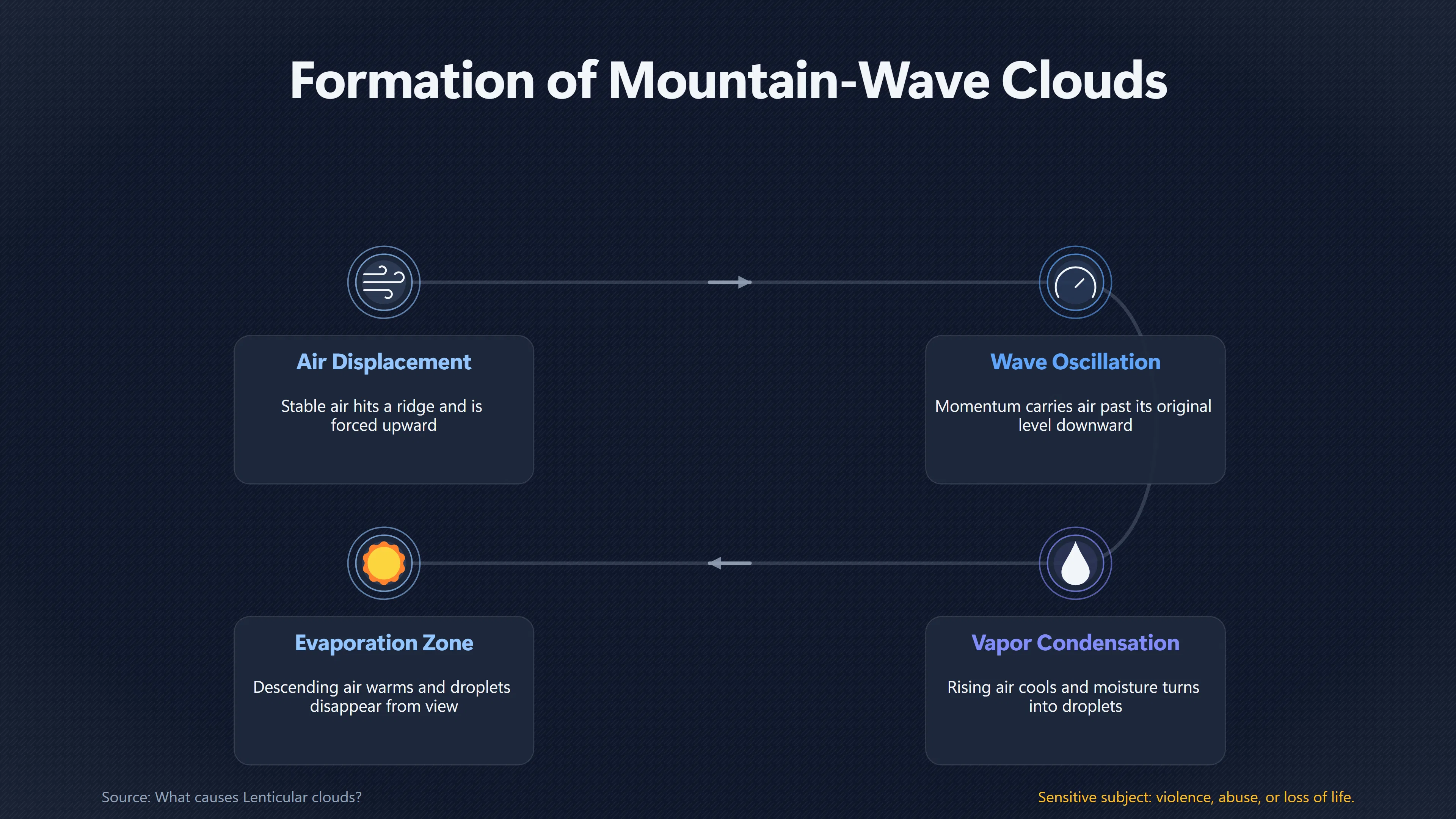
The process begins with terrain. When relatively stable air encounters a mountain or ridge, it is forced upwards. After crossing the barrier, the displaced air tends to return towards its original level, but its momentum can carry it past that level. Stability and gravity then act to restore it again, producing an oscillation downstream of the mountain. In favourable conditions this becomes a lee wave, or mountain wave, whose crests and troughs remain almost stationary relative to the ground even though the air itself continues travelling through them.[Met Office]metoffice.gov.ukOpen source on metoffice.gov.uk.
Moisture makes part of this otherwise invisible airflow visible. Air expanding as it rises towards a wave crest cools. If it cools to saturation, water vapour condenses into droplets and a cloud appears. Beyond the crest, the air descends, warms and becomes less saturated, causing the droplets to evaporate. The American Meteorological Society therefore defines mountain-wave clouds as clouds occupying the rising branches and crests of mountain waves, with sharp-edged lens or almond-shaped lenticular clouds among their most distinctive forms.[Glossary of Meteorology]ametsoc.orgOpen source on ametsoc.org.
The cloud is consequently better understood as a visible region within a flowing wave than as a fixed parcel of cloudy air. This distinction explains much of its unusual appearance.
Lenticular clouds can also develop at several levels. Where different sufficiently humid layers intersect the rising portions of the wave, several lenses may become visible above one another. The result resembles stacked plates or pancakes and can look even more engineered than a single lens. The University of British Columbia’s atmospheric-science material specifically notes that multiple humid layers can produce stacks resembling UFOs.[EOAS UBC]ubc.caOpen source on ubc.ca.
Meteorologically, lenticularis is a recognised cloud species rather than an informal nickname. The American Meteorological Society describes its elements as generally smooth lenses or almonds with sharp outlines. It occurs principally with cirrocumulus, altocumulus and, more rarely, stratocumulus; the familiar mid-level form is commonly called altocumulus standing lenticular.[Glossary of Meteorology]ametsoc.orgOpen source on ametsoc.org.
Why the cloud can hover in strong winds
The apparent contradiction is the feature most relevant to UFO reports: how can a cloud remain motionless when the wind is strong?
It does not remain motionless in the sense of containing the same air and droplets. The National Weather Service explains that an altocumulus standing lenticular cloud is continually developing around a wave crest and dissipating immediately downwind. Air and moisture therefore pass through the formation while the zone favourable for condensation stays approximately fixed.[National Weather Service]weather.govOpen source on weather.gov.
A useful analogy is the stationary shape of water flowing over a submerged obstruction. Individual water molecules move downstream, but the wave associated with the obstruction can stay in the same place. With lenticular clouds, the mountain supplies the disturbance and the atmosphere supplies the flowing medium.
This means strong wind is not evidence against the cloud explanation. In the right setting it is part of the explanation. The National Weather Service notes that the winds moving through an altocumulus standing lenticular cloud may be very swift, while mountain waves themselves can remain nearly stationary for hours.[National Weather Service]weather.govOpen source on weather.gov.
NASA’s description of New Zealand’s distinctive Taieri Pet provides a particularly clear real-world example. Strong north-westerly winds cross the Rock and Pillar Range on New Zealand’s South Island and generate the wave responsible for the cloud. NASA quotes meteorologist John Law of MetService explaining that the cloud remains almost stationary at the wave crest while strong winds blow through and shape it. Landsat 8 recorded the elongated formation on 7 September 2024.[NASA]nasa.govOpen source on nasa.gov.
This continuous replacement also helps explain why a lenticular cloud may maintain a remarkably clean outline. The visible boundary corresponds closely to where atmospheric conditions cross the threshold between condensation and evaporation. It need not develop the wandering, ragged edge that an observer may expect from an ordinary drifting cloud. The American Meteorological Society’s definition specifically emphasises the smooth form and sharp outline characteristic of lenticularis.[Glossary of Meteorology]ametsoc.orgOpen source on ametsoc.org.
Why it can look more like a craft than a cloud
The resemblance is not merely a product of imaginative witnesses. Lenticular clouds genuinely occupy a visually unusual part of the range of natural cloud shapes.
A well-developed formation can combine several misleading cues:
- A convex disc or lens profile. Seen from the side or obliquely, the cloud can reproduce the familiar silhouette of a cinematic flying saucer.
- Smooth, sharply defined edges. These contrast with the irregular, cauliflower-like or ragged outlines people commonly associate with clouds.
- Layering. Several lenticular clouds at different heights can produce a symmetrical stack resembling plates or a multi-tiered object.
- Little apparent horizontal motion. Because the cloud is tied to the standing wave rather than travelling with individual air parcels, it can appear to hover.
- Persistence. So long as the mountain-wave pattern, moisture and airflow remain favourable, the visible formation can survive while its constituent droplets are continually replaced.[ametsoc.org]ametsoc.orgOpen source on ametsoc.org.
Those characteristics explain why official meteorological sources themselves routinely reach for spacecraft analogies. The US National Weather Service says observers use descriptions such as “flying saucer” and “stack of pancakes”, while the Hong Kong Observatory has documented lenticular clouds over Kowloon resembling a pair of flying saucers.[National Weather Service]weather.govOpen source on weather.gov.
A striking modern example occurred over Cape Town in November 2015. Photographs showed multiple smooth formations suspended around the city’s mountainous skyline, prompting widespread “UFO cloud” comparisons. Meteorologists identified them as lenticular clouds generated by atmospheric waves over the area’s rugged terrain, including Table Mountain.[National Geographic]nationalgeographic.comOpen source on nationalgeographic.com.
The phenomenon is not restricted to spectacular mountain ranges. The Met Office says lenticular clouds are relatively unusual in the British Isles but do occur, and in January 2025 conspicuous formations photographed across northern Britain, including parts of northeast England, Cumbria and Scotland, again generated “UFO cloud” coverage.[Sky News]sky.comOpen source on sky.com.

Terrain and weather clues that support identification
Shape alone should not settle an identification. The stronger case for a lenticular explanation comes when the reported object’s appearance and its surroundings fit mountain-wave conditions.
The first clue is high ground, especially upwind of the observation. Lenticular clouds commonly develop over or downwind of mountains and ridges rather than directly above the terrain feature responsible for the wave. A witness may therefore see an apparently isolated disc in otherwise clear sky without recognising the mountain that generated it. Lee waves can continue for tens or even hundreds of miles downstream under favourable atmospheric conditions.[Met Office]metoffice.gov.ukOpen source on metoffice.gov.uk.
Wind direction is another useful test. Mountain-wave development is favoured when strong airflow crosses the relevant ridge approximately perpendicular to its orientation. The National Weather Service describes altocumulus standing lenticular clouds developing where relatively stable, fast-moving air crosses a topographic barrier oriented roughly across the upper-level wind.[National Weather Service]weather.govOpen source on weather.gov.
Atmospheric stability also matters. A mountain does not automatically produce a lenticular cloud whenever the wind blows. Stable air allows a displaced layer to oscillate rather than simply breaking into vigorous convection. There must also be sufficient moisture at the appropriate altitude for the rising portion of the wave to reach saturation. The wave itself can exist without any visible cloud if the air is too dry.[Met Office]metoffice.gov.ukOpen source on metoffice.gov.uk.
That leads to a practical identification pattern. A smooth oval reported near mountainous terrain becomes much more convincingly lenticular when several clues coincide: strong cross-mountain winds aloft, stable atmospheric layers, suitable moisture, a formation remaining nearly fixed relative to the terrain, and perhaps additional lenses arranged along the same mountain-wave system.
A National Weather Service case from Hawaii demonstrates how specific that reconstruction can become. On 25 November 2003, winds of roughly 40–60 mph developed above 10,000 feet over the Big Island. Mauna Loa and Mauna Kea, both rising to about 13,000 feet, disturbed that flow, producing waves downwind of their summits. With sufficient mid- and upper-level moisture available, lenticular clouds appeared around the wave crests.[National Weather Service]weather.govOpen source on weather.gov.
The hidden clue: turbulence around a serene-looking cloud
The visual impression can be deceptive in another way. A lenticular cloud may look extraordinarily calm while marking a much more energetic airflow.
Mountain waves can contain substantial vertical motion, and turbulent rotors may develop beneath wave crests. The Met Office warns that rotors associated with lee waves can produce severe turbulence, gusts and crosswinds. The US Federal Aviation Administration likewise treats lenticular clouds as visible indicators of mountain-wave conditions and notes the possibility of strong wind shear and turbulence, including rotor zones below a wave crest.[Met Office]metoffice.gov.ukOpen source on metoffice.gov.uk.
This provides useful corroborating evidence when evaluating an unusual sighting. Reports of strong or gusty winds near the terrain do not necessarily conflict with an apparently motionless “object” overhead. They can instead support a mountain-wave interpretation.
Equally important, the absence of a dramatic cloud elsewhere does not rule the mechanism out. The Met Office stresses that atmospheric waves can extend beyond the visible clouds, while the National Weather Service notes that mountain waves may exist when the air is too dry to reveal them. The saucer is therefore the visible condensation zone of a larger, mostly invisible airflow.[Met Office]weather.metoffice.gov.ukOpen source on metoffice.gov.uk.
When a lenticular explanation fits — and when it does not
Lenticular clouds are a powerful explanation for a particular class of UFO/UAP report, not a universal answer to unusual things in the sky. They fit best when the observation involves a broad, smooth lens or stacked-disc form that remains relatively stationary for minutes or longer, particularly in or downwind of mountainous terrain and under strong, stable airflow.
The explanation becomes weaker if a well-documented object performs movements inconsistent with the underlying wave: rapid independent translation across the terrain, abrupt directional changes, or a trajectory that cannot plausibly be produced by changes in the observer’s viewpoint or the evolving cloud. Likewise, calling an unidentified photograph “lenticular” merely because it is oval is not enough. Terrain, viewing direction, winds and weather conditions should agree with the proposed mechanism.
Conversely, apparent immobility should not be treated as evidence that an object must be solid. Lenticular clouds demonstrate precisely why that inference can fail. The pattern is stationary while the material is moving. Condensation continually constructs the cloud at one side of the wave and evaporation removes it at the other.[Center for Science Education]ucar.eduOpen source on ucar.edu.
For UFO/UAP assessment, that is the central diagnostic lesson. A smooth saucer that seems inexplicably parked in a windy sky can be unusual without being unexplained. When high ground, stable moist airflow and standing-wave geometry line up, the atmosphere is capable of maintaining a convincing hovering “object” whose apparent solidity is simply the visible boundary of water droplets continually forming and disappearing.
Amazon book picks
Further Reading
Books and field guides related to Why Lenticular Clouds Can Look Like Hovering UFOs. Use these as the next step if you want deeper reading beyond the article.
The Cloudspotter's Guide
Discusses the history, types, and cultural fascination with clouds and explains what they mean in terms of climate and weather.
The Cloud Collector's Handbook
Keep your head in the clouds with this whimsical guide to the wonders of the sky from an award-winning science writer. In The Cloud Colle...
A Field Guide to the Atmosphere
More than 400 photographs and line drawings illustrate every kind of atmospheric phenomenon: clouds of every type; storms, from cloudburs...

Light and Color in the Outdoors
First published 1993. Subjects: Color, Light, Popular works, Science: General Issues, Photographic equipment & techniques.
eBay marketplace picks
Marketplace Samples
Live-tested eBay searches with available results related to this page.
Selected fromUFO poster oneBay.co.uk.

Current eBay listing
I Want To Believe UFO Poster Giclée Fine Art Heavyweight Print


Current eBay listing
VINTAGE UFO FLYING SAUCERS COMIC ADVERTISING A2 POSTER PRINT
Endnotes
1.
Source: weather.metoffice.gov.uk
Link:https://weather.metoffice.gov.uk/learn-about/weather/types-of-weather/clouds/unusual-cloud-formations
2.
Source: weather.gov
Link:https://www.weather.gov/abq/features_acsl
Additional References
3.
Source: youtube.com
Title: What causes Lenticular clouds?
Link:https://www.youtube.com/watch?v=xz-57-3FPPE
Source snippet
Lenticular clouds UFO flying saucer UFO SPOTTED IN TASMANIA?! 👽😱 | What I Saw on Mount Wellington! #alien #trending...
4.
Source: youtube.com
Title: Mount Shasta’s neighboring lenticular clouds: explained
Link:https://www.youtube.com/watch?v=oyX2o2nF9UA
Source snippet
How do lenticular clouds form over mountains?...
5.
Source: youtube.com
Title: Bizarre UFO-like cloud hovers over Turkey
Link:https://www.youtube.com/watch?v=C3QiwAuTnCg
Source snippet
Mount Shasta's neighboring lenticular clouds: explained...
6.
Source: youtube.com
Title: How do lenticular clouds form over mountains?
Link:https://www.youtube.com/watch?v=mq8YStJ2J6A
Source snippet
How Do Lenticular Clouds Form?...
7.
Source: youtube.com
Title: How Do Lenticular Clouds Form?
Link:https://www.youtube.com/watch?v=u7CVY1vLXcY
Source snippet
What causes Lenticular clouds?...